
Scan to BIM for Revit: Workflow, Benefits and Accuracy Checks
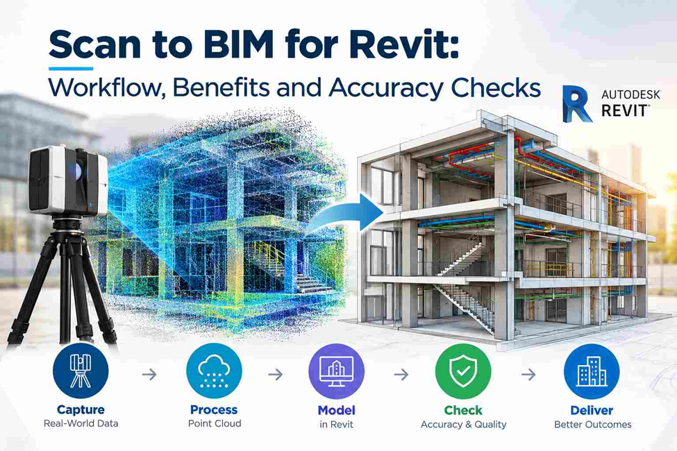
- A Revit model is only as reliable as the data behind it. Existing buildings often differ from old drawings due to modifications, relocated MEP services and changes in floor levels.
- Scan to BIM for Revit uses 3D laser scanning to capture these conditions as a point cloud. The data is registered, cleaned and linked to Revit, where it guides architectural, structural and MEP modeling.
- The workflow also requires proper coordinate control, modeling tolerances and QA/QC to ensure the final as-built BIM model reflects the surveyed conditions.
What Is Scan to BIM for Revit?
Scan to BIM combines 3D laser scanning with BIM modeling to create a digital representation of an existing building.
The scanner captures millions of X, Y and Z coordinates as a point cloud. The data is registered and cleaned in tools such as Autodesk ReCap before being linked to Revit.
The point cloud then guides the modeling of walls, slabs, columns, MEP systems and other building elements according to the required LOD and project specifications.
Scan to BIM Revit Workflow
A structured workflow helps maintain the relationship between the surveyed building, point cloud and final Revit model. The main stages are:
1. Define Survey and BIM Requirements
Before scanning starts, establish the project requirements:
- Survey area and site access
- Required survey accuracy
- Point-cloud density
- Coordinate system and project origin
- BIM disciplines to be modeled
- Required LOD
- Revit version
- Required deliverables
- QA/QC requirements
This prevents unnecessary modeling and ensures the final as-built BIM model matches the intended project use.
2. Capture Existing Conditions
3D laser scanning is used to record the existing building and site conditions.
The survey team selects scanner positions to achieve adequate coverage and reduce hidden areas. Depending on the project, terrestrial laser scanners, mobile scanning systems or other reality-capture equipment can be used.
The survey captures:
- Walls and floors
- Columns and beams
- Doors and windows
- Ceilings
- MEP services
- Structural elements
- Equipment and other visible components
3. Register the Point Cloud
Individual scan stations are combined into a single coordinated dataset through point cloud registration.
The process may use:
- Survey control points
- Targets
- Cloud-to-cloud registration
- Scanner positioning data
Registration should be checked before modeling because alignment errors can affect the entire BIM model.
4. Clean and Prepare the Scan Data
The registered point cloud is reviewed and cleaned before it is used in Revit.
Unnecessary information such as:
- Moving people
- Temporary objects
- Redundant points
- Unrelated areas
- Excess scan data
can be removed or separated.
The cleaned dataset can then be organized into manageable areas or zones for easier Revit modeling.
5. Establish Coordinate Control
The point cloud must be correctly aligned with the project coordinate system.
The team checks:
- Survey control
- Project origin
- Shared coordinates
- Elevation references
- Point-cloud positioning
Correct coordinate control allows the Revit model to work consistently with survey drawings, CAD files and other project models.
6. Link the Point Cloud Into Revit
The prepared RCS/RCP point cloud is linked into Revit as the geometric reference.
The modeler can then establish:
- Levels
- Grids
- Section views
- 3D views
- Section boxes
- Visibility settings
Section boxes are particularly useful for isolating individual floors, rooms or MEP areas during modeling.
7. Create the Revit Model
The point cloud provides the measured reference for creating native Revit elements.
Depending on the project scope, the model may include:
- Architectural elements
- Structural components
- Walls and slabs
- Doors and windows
- Columns and beams
- Pipes and ducts
- Cable trays
- MEP equipment
The model should follow the actual surveyed geometry rather than assuming that the existing building matches its original design drawings.
8. Apply the Required LOD
The required Level of Development (LOD) determines how much detail should be included in the BIM model.
The project may require:
- Existing-condition modeling
- Architectural detailing
- Structural modeling
- MEP modeling
- Coordination-ready geometry
- Detailed asset information
The model should contain the detail required for its intended use without creating unnecessary geometry.
9. Perform Scan-to-Model QA/QC
The completed Revit model is compared with the point cloud to identify discrepancies.
Important checks include:
- Wall alignment
- Floor and ceiling elevations
- Column and beam positions
- Opening dimensions
- MEP locations
- Model-to-cloud deviations
- Coordinate alignment
- Missing elements
- Incorrect geometry
Any significant discrepancy should be reviewed and corrected before the model is issued for design, coordination, renovation or construction.
Benefits of Scan to BIM for Revit Projects
1. Better Representation of Existing Conditions
Traditional drawings may not reflect later modifications.
A point-cloud-based workflow provides a measured record of the physical environment at the time of the survey. This is particularly useful for as-built BIM modeling, renovation and retrofit work.
2. Reduced Dependence on Manual Measurements
Manual measurements can require repeated site visits, particularly when a project contains irregular geometry or congested MEP areas.
3D laser scanning captures a large amount of spatial information during the survey, allowing the same dataset to be reviewed during the modeling stage.
3. Improved Revit Model Accuracy
A Revit model created directly from measured scan information has a stronger geometric basis than a model reconstructed only from incomplete drawings.
The actual achievable accuracy still depends on the scanner, survey control, registration quality, site conditions, modeling method and project tolerance.
4. Useful for Complex MEP Areas
Plant rooms, ceiling voids, risers and service corridors can contain overlapping pipes, ducts, cable trays and equipment.
A registered point cloud provides a three-dimensional reference for MEP Scan to BIM modeling and coordination.
It can help the team understand service locations and elevations before design changes are introduced.
5. Stronger Renovation and Retrofit Planning
Existing buildings rarely match their original drawings perfectly.
Scan to BIM provides a current digital representation that can be used as a reference when developing renovation, extension or retrofit designs.
This reduces the need to base new design decisions solely on historical documentation.
6. Easier Model Verification
The same scan data used to create the model can be retained as a reference for checking it.
This creates a useful connection between:
Survey → Point Cloud → Revit Model → QA/QC
That relationship is particularly valuable when the model will later be used for coordination or as-built documentation.
7. Better Coordination Between Project Teams
A structured BIM model can provide architects, structural engineers, MEP teams and contractors with a common spatial reference.
When the model is supported by reliable survey data, teams can evaluate existing conditions before making design or construction decisions.
Accuracy Checks for a Scan to BIM Revit Model
Scan to BIM accuracy depends on the survey equipment, control network, registration quality, modeling requirements and project tolerance. Key QA/QC checks include:
Point Cloud Registration
Review registration residuals, control-point agreement and scan alignment. Correct duplicate edges or misaligned surfaces before modeling.
Coordinate Check
Confirm the point cloud and Revit model use the correct coordinate system, control points and elevations.
Level and Elevation Check
Compare Revit levels with surveyed floor, slab and ceiling elevations, especially where slopes or construction variations exist.
Section-Based Geometry Check
Use Revit sections to compare walls, slabs, columns, beams and MEP elements directly against the point cloud.
Element Dimension Check
Verify critical dimensions such as wall thickness, slab thickness, openings, pipe diameters, duct sizes and equipment locations against the agreed project tolerance.
Model Completeness
Check that all required architectural, structural and MEP elements have been captured and modeled.
Clash and Clearance Review
After geometry validation, review the model for coordination conflicts and compare modeled conditions with the point cloud.
Common Problems That Affect Scan to BIM Accuracy
Several factors can affect the accuracy of a final Revit model:
- Poor Scan Coverage: Hidden or inaccessible areas may result in incomplete point-cloud data.
- Weak Registration: Misaligned scan stations can introduce positional errors.
- Incorrect Coordinates: Poor coordinate setup can cause the model to misalign with survey or project data.
- Unsupported Modeling: Modelers should avoid adding geometry that cannot be verified from the scan.
- Incorrect LOD: Too much or too little detail can make the model inefficient or unsuitable for its intended use.
- Skipped QA/QC: The final Revit model should always be checked against the point cloud before delivery.
Where Scan to BIM Is Used
Scan to BIM is useful when accurate information about an existing building or site is needed.
Common uses include:
- Existing building surveys
- As-built BIM models
- Renovation and retrofit projects
- MEP coordination
- Structural and architectural documentation
- Heritage building documentation
- Construction verification
- Facility management
- Clash and clearance checks
By combining 3D laser scanning with BIM modeling, survey data can be converted into a useful digital model for design, coordination and documentation.
Need Scan to BIM Support for Your Project?
Northern Engineering Surveys L.L.C provides 3D laser scanning, point cloud processing and Scan to BIM support for existing buildings and construction projects in Dubai and across the UAE. Our survey team can capture existing conditions and prepare accurate spatial data for BIM modeling, as-built documentation, MEP coordination and project verification.
If your project requires 3D laser scanning, point cloud data, as-built modeling or Revit-based Scan to BIM, contact Northern Engineering Surveys L.L.C to discuss the survey scope, required LOD and deliverables.
FAQs
1. What is Scan to BIM in Revit?
Scan to BIM in Revit is a workflow that uses 3D laser scanning and registered point-cloud data as the basis for creating a structured BIM model of an existing building or site.
2. How does a point cloud get into Revit?
The captured scans are first registered and processed, commonly using Autodesk ReCap. The prepared RCS or RCP point cloud can then be linked into Revit and used as the geometric reference for BIM modeling.
3. What is the difference between Scan to BIM and Scan to Revit?
Scan to Revit generally describes the modeling stage where scan data is used to create a Revit model. Scan to BIM covers the broader workflow, including survey capture, registration, processing, modeling, coordination and QA/QC.
4. How is Scan to BIM accuracy checked?
Accuracy can be checked by reviewing scan registration, coordinate control, levels, sections, dimensions and model-to-point-cloud deviations. The checks should be based on the project’s specified tolerance and modeling requirements.
5. Can Scan to BIM be used for MEP modeling?
Yes. Registered point clouds can provide a spatial reference for modeling pipes, ducts, cable trays, equipment and other MEP components, particularly in congested existing spaces.
6. Is a point cloud itself a BIM model?
No. A point cloud is measured spatial data made up of individual points. A BIM model contains structured building elements such as walls, slabs, columns, doors, pipes and equipment. The point cloud can be used as the reference for creating the BIM model.