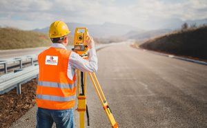
Topographic Surveys | Surveying Experts
Accurate topographic surveys provide essential data for seamless property development and precise construction planning.
Detailed Terrain Mapping for Optimal Design
Inaccurate terrain data often leads to design flaws and costly rework. Our topographical surveys deliver detailed contour maps and 3D models that support effective planning and construction. With state-of-the-art technology and local expertise, Northern Engineering Survey provides essential land intelligence that helps optimize earthworks, drainage solutions, and site layouts, ensuring smoother development and successful project outcomes.

Other Related Services

Building Survey

BIM Modeling

As-Built Survey
Company Profile
Our Business Statistics
Why Choose Us
High-Tech Total
Stations
Utilizing high-precision total stations, we achieve sub-millimeter accuracy with automated measurements and error-free data transfer for reliable, fast setups.
Seamless Data Integration
Our surveying and CAD services integrate flawlessly, ensuring maximum data integrity, eliminating loss, and delivering reliable, accurate results for smooth project execution.
Proven Experience & Expertise
Expertise Northern Engineering Survey boasts a comprehensive portfolio of successful projects, reflecting high client satisfaction and a trusted industry reputation for quality.
Tailored Project Solutions
We offer bespoke solutions supporting precise site planning for construction, land/Environmental assessments, and optimized municipal/urban planning.
Hear From Our Clients
NES Dubai showcases a diverse range of completed projects, indicating their expertise and rel“Professional, Prompt, and Precise!”
We’ve worked with NESDubai on multiple residential projects across the UAE. Their consistent quality and use of modern equipment set them apart from other survey firms.
“Trusted Survey Partner for Our Developments” — Omar Khalid, Director.Their BIM modeling and control point services helped us streamline our structural planning process. Communication was clear throughout the project. Will definitely work with them again.
“Highly Accurate and Detailed Surveys” — Lina Haddad, Structural Engineer.From GPS surveys to setting out for our commercial site, NESDubai’s team was on point. Their quick turnaround and technical expertise saved us both time and cost.
.“Reliable, Responsive, and Results-Driven” — James Brooks, Site Manager.Topography Survey FAQ
Why are Topographical surveys important for real estate activities?
Topographical surveys provide detailed data about land features, aiding in accurate planning and design. They help identify potential risks and ensure legal boundary clarity. This makes them essential for informed real estate development and regulatory approvals.
How accurate are topographical surveys?
The accuracy of a topographical survey depends on the methods and equipment used. Modern surveying techniques, such as GPS and 3D laser scanning, can achieve high levels of precision, ensuring that the data collected accurately represents the site’s features and elevations.
What is the difference between a boundary survey and a topographic survey?
A boundary survey identifies and marks the exact property lines and corners of a piece of land to establish legal ownership boundaries. A topographic survey, on the other hand, maps the physical features and elevations of the land, showing natural and man-made details like hills, trees, buildings, and utilities. In short, boundary surveys focus on legal limits, while topographic surveys focus on land’s physical characteristics.
How much does a topographic survey cost?
This all depends on the size of the area and the output you are requiring.
- All surveys are different and require different detailing.
- So the length of time on site can vary which will impact the cost.
- But essentially, we will cater for your budget and your needs and will be honest and open with the possibilities and costs.
How long does a topographic survey take to complete?
The duration of a topographic survey depends on the size, complexity, and accessibility of the site. Small residential lots may take 1–2 days, while large or intricate sites can take several days to weeks. Additional time may be needed for processing and delivering the final survey report and drawings.
NES Dubai handled all our demarcation and as-built survey requirements perfectly. Their team was knowledgeable and ensured everything was approved by Dubai Municipality without delays.
“Excellent Service for Construction Permits” — Fatima Al Suwaidi, Architect.