
Boundary Survey vs Plot Demarcation: Key Differences in Dubai
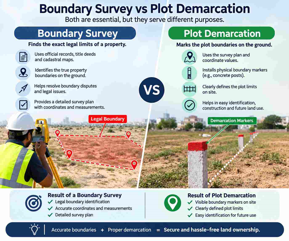
Boundary Survey and Plot Demarcation are closely connected surveying services, but they are not always carried out for the same reason.
A property owner may need to know the exact position of a plot boundary. A contractor may need those boundary points physically identified before starting site work. An engineer may need reliable coordinates to use in a design. These situations can involve both services, but the survey work and final requirement can be different.
Understanding the difference helps property owners, developers and contractors choose the right survey before work starts.
What Is a Boundary Survey?
A Boundary Survey establishes the position of a property’s legal boundaries using available property records and measurements taken at the site. The surveyor compares recorded information with actual site conditions rather than assuming that existing walls, fences, or structures mark the property line. The survey provides accurate boundary information for property verification, planning, design, and construction work.
What Is Plot Demarcation?
Plot Demarcation identifies and marks a property’s boundary on the ground. The survey team locates the plot corners and required boundary points using established survey information. This is especially useful for vacant plots where there are few visible features showing the property limits. Before construction, clear demarcation helps contractors work from accurate boundary references rather than estimating from nearby walls, roads, or neighbouring properties.
Boundary Survey vs Plot Demarcation
The simplest distinction is this:
A Boundary Survey establishes and documents boundary information. Plot Demarcation transfers that information to identifiable positions on the ground.
There can be overlap between the two. A demarcation exercise still requires accurate survey measurements, and a boundary survey may include the physical identification of boundary points.
The difference usually comes down to the purpose and scope of the work.
| Boundary Survey | Plot Demarcation |
| Establishes the position of property boundaries | Identifies boundary points on the site |
| Focuses on measurement, verification and documentation | Focuses on physical boundary identification |
| Can include coordinates and plot dimensions | Can include marked plot corners or boundary points |
| Useful when the boundary position needs to be checked | Useful before construction or site work |
| Can investigate differences between records and site conditions | Makes the established boundary easier to identify on site |
How Is a Boundary Survey Carried Out?
A boundary survey normally starts before the survey equipment is set up.
The surveyor first needs to understand the purpose of the assignment and the available property information. Previous survey information, approved drawings or other relevant records may be reviewed as required by the project.
The field team then examines the site and looks for existing boundary points and physical features that may help with the survey.
Survey-grade equipment such as GNSS receivers and Total Stations can be used to collect the required coordinates and measurements. Total Station surveying can provide precise angle and distance observations, while GNSS can be used for coordinate positioning and survey control.
The collected measurements are then processed and checked before the final survey information is prepared.
This is important because an existing fence or wall may not necessarily sit exactly on the property boundary.
How Does Plot Demarcation Work?
Plot demarcation is more focused on taking the established boundary information and locating it at the property.
A typical site sequence may involve:
- Checking the available plot information.
- Establishing or verifying the survey reference.
- Locating existing boundary points where available.
- Measuring the required coordinates.
- Identifying the plot corners.
- Marking or indicating the required boundary points.
- Providing the agreed survey information or plan.
The exact method depends on the site and the project requirements.
If an old boundary point is missing or cannot be relied upon, the surveyor may need to determine its position from the available survey information rather than simply placing a marker where the old point appears to have been.
When Do You Need a Boundary Survey?
A Boundary Survey may be appropriate when the exact position of the property limits needs to be established or checked.
Common situations include:
- Before developing a plot
- Before construction close to a property boundary
- When existing boundary markers are missing
- When plot dimensions need to be verified
- When a wall or fence appears to be incorrectly positioned
- When neighbouring property limits are unclear
- When survey information is required for planning or engineering work
The exact survey requirement should be determined from the purpose of the project and the applicable authority requirements.
When Is Plot Demarcation More Suitable?
Plot Demarcation is particularly useful when the boundary information is already available but the project team needs the plot limits identified physically at the site.
For example, a contractor preparing to start work on a vacant plot may need the corners located before setting out the building.
It can also be useful where existing boundary markers have become difficult to identify because of previous site activities, landscaping or surrounding development.
The practical objective is straightforward: make the plot boundary identifiable where the work is taking place.
The right approach depends on whether the project needs boundary verification, physical marking, or both.
Boundary Survey or Plot Demarcation: Which One Do You Need?
There is no single answer for every property.
If the main question is “Where exactly is my property boundary?”, a Boundary Survey may be the appropriate starting point.
If the boundary position is already established and the requirement is “Show me where those boundary points are on the site,” Plot Demarcation may be the more suitable service.
If the project involves construction, missing boundary points or uncertainty about the existing plot limits, both may form part of the same surveying requirement.
The important thing is to define the purpose before the survey starts. That allows the surveyor to select the appropriate field measurements, equipment and deliverables rather than collecting information that the project does not need.
Need Boundary Survey or Plot Demarcation in Dubai?
Northern Engineering Surveys L.L.C provides surveying support for property, construction and development projects in Dubai. Our survey teams can assist with Boundary Survey, Plot Demarcation, GPS Survey, Total Station Survey, Topographic Survey and construction surveying based on the requirements of the site.
If you are unsure which service your project requires, share the available plot information and explain what you plan to do on the property. The survey scope can then be matched to the actual requirement.
Frequently Asked Questions
1. Is Boundary Survey the same as Plot Demarcation?
No. A Boundary Survey focuses on establishing and documenting the position of a property boundary. Plot Demarcation focuses on identifying the boundary points physically at the site. Depending on the project, both services may be required.
2. Do I need a Boundary Survey before construction in Dubai?
If construction depends on the exact position of the property boundary, confirming the boundary before work begins is advisable. This is particularly important when construction is close to the plot limit.
3. Can a surveyor use an existing wall as the property boundary?
Not automatically. A wall or fence is a physical feature and may not correspond exactly with the recorded property boundary. Survey measurements and relevant property information should be checked before treating it as the boundary.
4. What equipment is used for Boundary Survey?
Surveyors may use GNSS/GPS equipment, Total Stations and other survey instruments depending on the required accuracy, site conditions and survey scope.
5. What happens if a plot corner marker is missing?
The surveyor can investigate the available survey information and site evidence to determine the required boundary position. The appropriate method for reinstating or marking the point depends on the project and applicable requirements.
6. Should I choose Boundary Survey or Plot Demarcation?
Choose based on the purpose. If you need the boundary position measured and documented, a Boundary Survey may be appropriate. If the boundary information is already established and you need the plot corners identified on site, Plot Demarcation may be sufficient. Some projects require both.