
Introduction
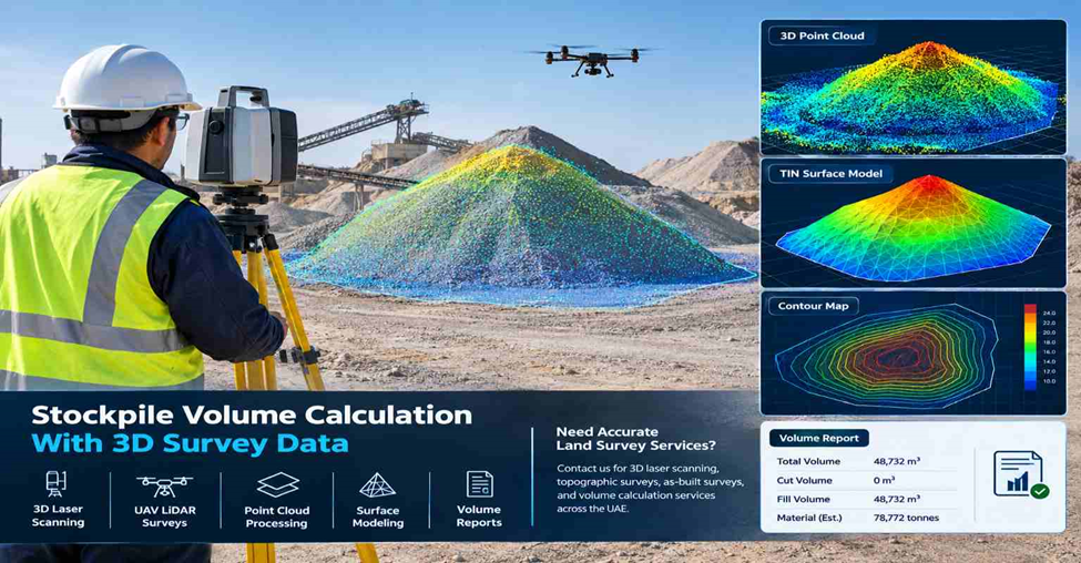
Stockpile volume calculation is used to measure how much material is stored on a site. Instead of estimating piles by eye or using manual measurements, surveyors use 3D survey data to calculate the volume more accurately.
With 3D laser scanning, UAV LiDAR, or other surveying methods, millions of surface points are captured and converted into a digital model. This helps project teams track inventory, monitor excavation or filling work, and compare stockpile changes over time.
What 3D Data Is Used for Stockpile Volume Calculation?
Surveyors collect detailed surface information before calculating volume. The main data used includes:
- 3D point cloud: Millions of measured points that capture the stockpile surface.
- Survey coordinates: Exact X, Y, and Z positions for every point.
- Surface model: A digital representation of the stockpile shape.
- Stockpile boundary: Defines the exact area included in the calculation.
- Survey control points: Keep the survey aligned with the project coordinate system.
How Are Stockpiles Captured Using 3D Scanning?
Different survey methods are used depending on the site size and material type.
- Terrestrial 3D laser scanning captures detailed stockpile surfaces from multiple scan positions.
- UAV LiDAR or drone surveys are useful for large stockpiles, quarries, and open storage yards.
- Mobile mapping can quickly capture stockpiles along roads or industrial sites.
The survey method is selected based on access, safety, coverage area, and required accuracy.
How Is a 3D Point Cloud Prepared for Volume Measurement?
After fieldwork, the survey data is cleaned and organized before calculations begin.
- Combine multiple scans into one point cloud.
- Remove unwanted objects like vehicles or equipment.
- Check survey control points for alignment.
- Mark the stockpile boundary clearly.
- Keep only the points needed for volume measurement.
How Is a Surface Model Created From 3D Data?
The processed point cloud is converted into a surface that represents the stockpile.
- Generate a TIN (Triangulated Irregular Network) surface.
- Create a reference ground surface if needed.
- Build the stockpile surface from the scanned data.
- Apply boundaries and breaklines to define the shape correctly.
This surface is what the software uses to calculate volume.
How Is the Stockpile Volume Calculated?
The calculation compares the stockpile surface with a base or reference surface.
- Define the base surface.
- Generate the stockpile surface.
- Compare both surfaces inside the selected boundary.
- Calculate the volume between them.
The final output can include total volume, cut volume, fill volume, and material quantities.
What Types of Stockpiles Can Be Measured?
3D survey data works for many types of bulk materials, including:
- Sand stockpiles.
- Gravel and aggregates.
- Soil and earthworks.
- Crushed stone.
- Quarry materials.
- Construction waste.
- Bulk industrial materials.
The same workflow can be used for both small construction sites and large industrial yards.
What Are the Final Survey Deliverables?
After processing, surveyors provide digital outputs that project teams can use immediately.
- Stockpile volume report.
- 3D point cloud.
- TIN surface model.
- Contour drawings.
- CAD and GIS files.
- PDF survey drawings.
- Quantity comparison reports when needed.
These deliverables support planning, reporting, and inventory management.
Why Use 3D Survey Data for Stockpile Measurement?
3D survey data makes stockpile measurement faster and easier to repeat throughout a project.
- Captures the full stockpile surface.
- Reduces manual estimation errors.
- Makes progress comparisons simple.
- Creates a digital record for future surveys.
- Supports accurate material tracking.
It is a practical solution for construction, quarry, mining, and industrial projects.
Stockpile Volume Calculation With 3D Laser Scanning
At Northern Engineering Surveys L.L.C., stockpile volume calculation is carried out using 3D laser scanning and other advanced surveying methods based on site requirements.
Our survey workflow includes accurate data capture, point cloud processing, surface modeling, and detailed volume reports for construction, quarry, infrastructure, and industrial projects across the UAE.
Whether you need a one-time stockpile measurement or regular volume monitoring, our team provides survey data that is ready for engineering and project management use.
Need Accurate Land Survey Services?
Northern Engineering Surveys L.L.C. provides 3D laser scanning, topographic surveys, as-built surveys, and volume calculation services across Dubai and the UAE.