
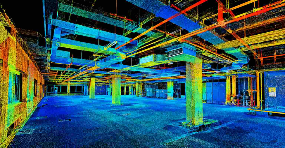
Construction teams often need more than measurements from a site. They need a clear digital record of what is actually there — walls, floors, columns, MEP services, structures, equipment and other site elements.
A point cloud scanning service captures this existing condition as a dense 3D dataset. The data can then be used for CAD drawings, as-built documentation, BIM modelling, coordination and other construction workflows.
But the quality of the final point cloud depends on more than the scanner itself. Scan coverage, survey control, registration, site conditions and data processing all affect the result.
What Is a Point Cloud Scanning Service?
A point cloud scanning service uses 3D laser scanning or LiDAR-based equipment to capture the physical dimensions of a site.
The collected points are combined into a registered 3D dataset that can show:
- Building geometry
- Structural elements
- MEP services
- Equipment and plant
- Floors, walls and ceilings
- Pipework and ducts
- Existing site conditions
The point cloud can then become the measurement base for CAD drawings, BIM models or as-built documentation.
What Should You Check Before Choosing a Point Cloud Scanning Service?
The scanner specification is only one part of the job. For a construction project, check these points before selecting a service:
1. Scan coverage
Ask how the survey team will handle areas hidden behind:
- Columns
- Walls
- Equipment
- Pipework
- Structural members
- Ceiling services
Multiple scan positions may be required where line-of-sight is restricted.
2. Survey control
For projects requiring controlled survey information, ask how the point cloud will be tied to the project coordinate system.
Depending on the project, this may involve:
- GNSS control
- Total station observations
- Existing control points
- Survey benchmarks
- Coordinate transformation
3. Registration quality
Individual scans need to be registered into one coordinated dataset.
A proper workflow should include:
- Scan registration
- Control checks
- Registration error review
- Removal of unwanted data
- Final quality checking
4. Required deliverables
Do not request only “a point cloud” without defining how the data will be used.
Typical project outputs can include:
| Project requirement | Possible output |
| Existing-condition record | Registered point cloud |
| Architectural documentation | Floor plans, elevations and sections |
| As-built survey | As-built drawings and point cloud |
| BIM workflow | Point cloud for BIM modelling |
| MEP coordination | MEP-related measured data |
| Design verification | Point cloud and comparison data |
Where Is Point Cloud Scanning Used in Dubai?
Point cloud data can be useful when the existing site is more complicated than the available drawings suggest.
Common applications include:
- Existing building surveys – Capture current dimensions before renovation or modification.
- As-built surveys – Record constructed conditions for project documentation.
- MEP coordination – Capture congested services, ducts, pipes and equipment.
- Construction verification – Compare measured site conditions with drawings or models.
- Scan-to-BIM – Use the measured point cloud as the basis for creating an existing-condition model.
- Industrial surveys – Capture plant rooms, equipment, structures and pipework.
- Fit-out projects – Obtain accurate interior measurements before installation work.
Point Cloud Scanning for As-Built Documentation
One practical use of point cloud scanning is documenting the condition of a completed or partially completed building.
Instead of relying only on old drawings, the survey captures the physical site.
The workflow can be:
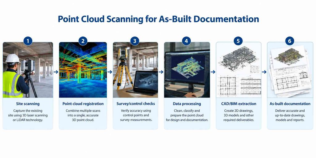
This can help identify differences in:
- Wall positions
- Floor levels
- Structural elements
- MEP routes
- Equipment locations
- Openings and penetrations
Point Cloud Scanning for CAD and BIM
A point cloud does not automatically become a finished BIM model or CAD drawing.
The required output should be decided before the survey starts.
For example:
Point cloud → Floor plans / elevations / sections
or
Point cloud → Existing-condition BIM model
or
Point cloud → MEP documentation
This avoids collecting a large dataset without knowing how it will be used later.
Dubai’s Growing Use of 3D Geospatial Data
There is already a practical example of large-scale 3D data collection in Dubai.
Dubai Municipality has reported using laser-based 3D imaging to produce dense point clouds and 3D models of landmarks and buildings. Its published information states that the system produced point clouds with an accuracy of around 5 cm for the covered landmarks.
Dubai Municipality’s GIS Centre also provides geospatial maps and data to government entities, consultants and contractors, and its GIS work includes 2D and 3D mapping.
For construction projects, this shows why structured 3D spatial data is becoming increasingly useful beyond traditional 2D survey information.
Official UAE/Dubai reference: Dubai Municipality – GIS Projects
Point Cloud Scanning and Dubai BIM Requirements
Point cloud data can also fit into the wider BIM workflow.
Dubai Municipality has published BIM requirements and circulars covering the use of Building Information Modeling in the construction sector. A 2023 circular addressed mandatory BIM model submission for certain building permit applications.
This makes it useful to plan the point cloud survey around the final BIM requirement rather than treating scanning as a separate activity.
How Much Does Point Cloud Scanning Cost in Dubai?
There is no single price for every point cloud survey.
The project cost can change based on:
- Site size
- Number of scan positions
- Building complexity
- Accessibility
- Required accuracy
- Survey control requirements
- Data processing
- CAD extraction
- BIM modelling
- Required turnaround time
A small interior survey and a large industrial facility will have very different scanning requirements.
What Makes a Point Cloud Service Suitable for Your Project?
Before appointing a survey company, ask:
- What area needs to be scanned?
- What accuracy is required?
- Is survey control required?
- What coordinate system should be used?
- Are there restricted or inaccessible areas?
- Do you need the raw/registered point cloud?
- Do you need CAD drawings?
- Do you need a BIM model?
- What file format is required?
- How will the final data be checked?
Getting these details clear at the beginning makes the scanning workflow much easier to manage.
Why Choose Northern Engineering Surveys for Point Cloud Scanning?
Northern Engineering Surveys LLC provides surveying and engineering services in Dubai, supporting construction and project requirements.
For a point cloud scanning project, the required scope can be planned around the site conditions and final deliverables — whether the requirement is point cloud data, CAD documentation, as-built information or BIM-related survey data.
Need point cloud scanning support in Dubai? Contact Northern Engineering Surveys to discuss your project requirements.