
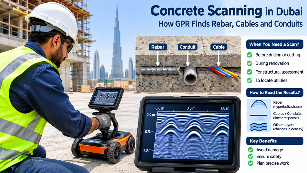
A concrete slab looks solid and uniform. Inside, it often holds a dense mesh of steel bars, tensioned cables, electrical conduits and the odd void. One careless core drill can cut through any of them, and the result ranges from a damaged bar to a cut cable, a service outage or an injury. In Dubai, where buildings pack many floors of services into tight spaces, the risk is real even on a small fit-out job.
Concrete scanning removes the guesswork. This guide explains how it works, what it finds, when you need it, and how to read the results. If your site also has buried services outside the building, our utility survey page covers that side.
Understanding Concrete Scanning and Its Role in Safe Construction
Concrete scanning is a non-destructive test. It locates and measures what lies inside concrete without breaking it. A technician scans the surface, then marks the position of rebar, cables, conduits and voids so that the crew can drill, core or cut with a clear picture of the slab.
The benefits are practical. A scan protects workers, protects the structure and prevents the delays that follow a hit service. A cut post-tensioned cable, for example, can seriously damage a slab, so nobody should guess where one runs.
Principles of Ground Penetrating Radar in Concrete Scanning
Most concrete scanning relies on ground penetrating radar, or GPR. A GPR unit sends short radio pulses into the concrete through an antenna. The pulses bounce back wherever the material changes, such as at a steel bar, a plastic conduit or an air gap. The unit records how long each echo takes and how strong it is, and the software turns those echoes into an image.
The operator moves the unit across the surface while a wheel records its position. Because the echo time reveals depth, each object appears at its position and depth on the screen. Concrete X-ray is an older method. GPR has largely replaced it because it works from one side, gives results on site and does not use ionising radiation. Other tests exist for other questions. Half-cell corrosion mapping, for instance, checks for corrosion in reinforcement, while GPR shows what sits where.
Embedded Elements a Concrete Scan Can Detect
A typical GPR scan locates:
- Reinforcing bars and mesh, including their spacing
- Post-tensioned cables, often called tendons
- Electrical conduits and pipes, both metal and plastic
- Voids and honeycombing inside the concrete
- Slab thickness
- Signs of moisture, delamination or deterioration, which show up as changes in the radar signal
The result is a map of the slab’s hidden contents, which no drawing can match if the drawings are old, incomplete or missing.
Applications: When to Scan Before Drilling, Coring or Cutting
Scan first whenever you cannot be sure what lies inside the concrete. The usual situations are:
- Core drilling and anchor fixing for new equipment, partitions or facades
- Saw cutting openings for stairs, ducts, lifts or services
- Renovation and demolition work on existing buildings
- Buildings with no reliable drawings, or drawings that no longer match the site
- Structural inspections that need rebar spacing, cover or slab thickness
Where drawings are missing, an as-built survey records the building’s geometry, while a concrete scan records what lies inside it. A 3D laser scan captures visible surfaces only, so it does not replace a concrete scan.
The Concrete Scanning Process: From Site Preparation to Data Capture
A typical job follows these steps:
- Briefing : The client explains what work will follow, where, and which drawings exist.
- Site preparation : The team clears debris from the scan area, checks access and tells occupants about the work. A smooth, dry surface gives the best results.
- Grid setup : The technician marks a grid on the surface to guide the scan lines.
- Scanning : The technician passes the GPR unit along the grid lines in two directions so that every object appears from both sides.
- Interpretation and marking : The operator reads the radar image on site and marks the findings on the surface.
- Reporting :The team records the results in photographs, plans or a short report.
The equipment finds the signals, but the operator reads them. Operator training and experience decide how reliable the marking is, so ask who will run the scan.
Interpreting Scan Results: Depth, Reinforcement Spacing and GPR Limitations
A scan gives three kinds of answers. It shows where an object sits on the surface, how deep it lies, and how the objects relate to each other, such as the spacing between bars.
GPR has limits, and you should know them:
- Depth : Standard slab scanning typically reaches around 45 to 60 cm, though the range depends on the antenna and on the concrete.
- Dense reinforcement : A tight mesh can hide objects beneath it.
- Moisture : Wet concrete weakens the signal and shortens the range.
- Material identification : The radar shows reflections, not labels. The operator infers whether an object is a bar, a cable or a pipe from its shape, depth and behaviour.
A scan reduces the risk to a very low level, but it does not remove the need for care. Drill in a clear zone, and stop work and re-scan if anything unexpected appears.
Marking, Reporting and Safe Work Planning After the Scan
The technician usually marks the findings directly on the concrete with paint or chalk, so the crew can see them. A written or drawn record then goes to the engineer and the contractor, with depth readings and photographs.
Use that record to choose drilling points, plan cutting lines and decide where reinforcement needs a structural engineer’s attention. Cutting any structural element needs an engineer’s approval first. The findings can also feed a BIM model, and our guide to how an AutoCAD structural drawing takes shape shows how that information can move into drawings.
To see how we approach site checks and data quality, read our survey methodology and survey equipment pages.
Scan First, Then Proceed With Confidence
Concrete scanning costs little compared with the cost of a cut cable or a damaged slab. A short scan before you drill, core or cut gives your crew a clear map of what lies inside, and it keeps the project on schedule.
If you plan work on a concrete structure, contact our team and we will help you decide what to scan. You can also see the kind of work we deliver on our project references page, or read about our wider services on our land surveying in Dubai page.
Frequently Asked Questions
1. What is concrete scanning?
It is a non-destructive test that locates rebar, cables, conduits and voids inside concrete. Technicians usually use ground penetrating radar.
2. How deep can a concrete scan see?
It depends on the antenna and the concrete. Standard slab scans typically reach around 45 to 60 cm. Ask your provider for the range on your slab.
3. Is concrete scanning safe for the structure and the people nearby?
Yes, GPR sends low-power radio waves and does not damage the concrete. It does not use the ionising radiation that concrete X-ray does, so work nearby can often continue.
4. Do I need a scan before drilling or coring?
You should scan whenever you cannot be sure what lies inside the concrete. Many building managers and contractors also require it, so check your site rules.
5. How does concrete scanning differ from a utility survey?
Concrete scanning looks inside a slab or wall at close range. A utility survey locates buried services in the ground across a site.