
Setting Out Using a Total Station: Step-by-Step Process for Building Projects
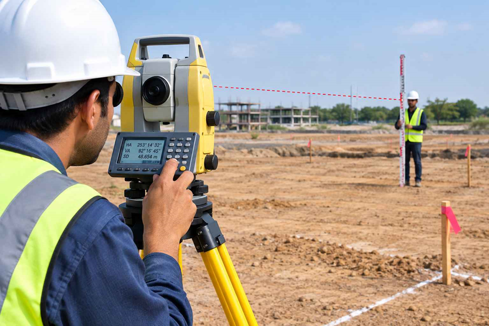
A building can be designed to the millimetre, but those dimensions still have to be transferred correctly onto the ground before construction can follow the drawings.
This is where setting out using a Total Station becomes important. The surveyor takes the coordinates and dimensions from the approved design, relates them to the established site control, and marks the required positions on the ground for the construction team.
For a building project, setting out is not simply a matter of placing a few points. The surveyor has to work with control points, building grids, coordinates, levels, structural drawings and site conditions while checking that each stage agrees with the project reference.
Here is how the process normally works.
1. Review the Approved Construction Drawings
Before going to the site, the survey team needs to understand what has to be set out.
The drawings may contain:
- Building grid lines
- Column locations
- Foundation positions
- Wall lines
- Structural dimensions
- Centre lines
- Finished floor levels
- Road and external works
- Coordinates for important construction points
The surveyor also checks whether the drawings use the same coordinate system and reference information as the site survey.
This step is easy to overlook. If the surveyor is working from an outdated drawing or the wrong revision, even accurate measurements can put construction in the wrong position.
2. Identify the Project Survey Control
The next step is to identify the control points that will be used as the reference for setting out.
These points provide the connection between the project’s coordinate system and the physical site.
The surveyor checks:
- Horizontal coordinates
- Reduced levels where applicable
- Control-point descriptions
- Visibility between control points
- Condition of the markers
- Consistency with the available project information
The control network needs to be reliable because the building positions being marked will ultimately depend on it.
If there is any doubt about a control point, it should be investigated before construction points are transferred.
3. Prepare the Design Coordinates
The positions shown on architectural or structural drawings have to be converted into usable survey coordinates.
For example, the survey team may need coordinates for:
- Building corners
- Grid intersections
- Column centres
- Foundation corners
- Shear wall positions
- Core locations
- Structural axes
The surveyor loads or enters the required coordinates into the field controller associated with the Total Station.
At this stage, the important question is not simply whether a coordinate has been entered. It is whether the coordinate belongs to the correct drawing revision and project reference.
4. Set Up the Total Station on a Known Point
Once the required points are prepared, the surveyor selects a suitable control station from which the work can be carried out.
The Total Station is positioned over the known point and connected to the project coordinate system.
A known reference point is then used to establish the instrument orientation.
The surveyor checks the setup before starting the actual setting-out work.
This is different from simply setting up the instrument and immediately starting to mark points. The instrument needs to know both where it is and which direction the project coordinates are running.
5. Establish the Working Direction
The Total Station needs a reliable orientation before design coordinates can be transferred.
A backsight or another known control point can be used to establish the direction.
The surveyor checks the observed reference against the known project information.
If the orientation is wrong, every point subsequently set out from that station can be affected.
That is why experienced surveyors do not treat the backsight as a formality. It is one of the main checks connecting the instrument to the project coordinate system.
6. Stake Out the First Building Points
With the instrument oriented, the surveyor can begin transferring the design positions to the site.
The Total Station compares the current position of the prism with the selected design coordinate and guides the surveyor towards the required location.
Depending on the construction stage, the marked point could represent:
- A building grid intersection
- A column centre
- A foundation corner
- A wall line
- A structural axis
- A pile location
- An external works position
The point is then physically marked using the method appropriate for the site and construction activity.
The surveyor should make sure the mark is clear and can be identified by the construction team.
7. Establish Building Grid Lines
For many building projects, grid lines are more useful than isolated points.
Once the main grid has been established, construction teams can use it as a reference for locating columns, walls, foundations and other structural elements.
The surveyor may set out several grid intersections and transfer the grid to suitable reference marks away from areas where construction activity could disturb them.
This becomes particularly useful as excavation and structural work progress.
A well-maintained grid gives different trades a common reference instead of each team working from separate measurements.
8. Set Out Foundations and Structural Positions
After the main building reference has been established, the surveyor can transfer individual construction positions.
For foundations, this may include:
- Foundation corners
- Centre lines
- Footing positions
- Pile locations
- Column centres
- Structural walls
The required points depend on the drawings and the construction sequence.
The surveyor should also consider whether the marks will survive the next stage of work. A point marked in an area that will immediately be excavated may need to be transferred to an offset position that remains accessible.
9. Use Offset Points Where Direct Marks May Be Lost
Construction sites change quickly.
Excavation, formwork, concrete placement and other activities can remove the original survey marks.
For this reason, surveyors may establish offset or reference points away from the immediate construction area.
For example, a building line can be transferred to a secure location outside an excavation zone. The construction team can then use that reference to recover the required position later.
This is a practical part of setting out that is often more important than simply achieving the first measurement.
The point needs to remain useful after the site changes.
10. Check the Set-Out Points Independently
A point should not automatically be accepted just because the Total Station indicates that it has reached the design coordinate.
The surveyor can carry out independent checks using other control points, measurements or repeated observations.
Useful checks may include:
- Re-observing important points
- Checking distances between grid points
- Comparing perpendicular building lines
- Checking diagonals
- Confirming offsets
- Checking against another control station
- Comparing the marked position with the construction drawing
For a building, these checks can help identify an incorrect coordinate, drawing revision, setup problem or marking error before construction progresses.
Common Problems During Total Station Setting Ou
The Total Station itself is rarely the only thing that determines the quality of the result. Problems can also come from the information being used or from conditions on site.
Wrong Drawing Revision
A surveyor can accurately set out the wrong design if an old drawing is used.
The drawing revision should therefore be checked before coordinates are prepared.
Disturbed Control Points
Construction activity can move, damage or remove survey markers.
Control points should be checked before they are used for further setting out.
Incorrect Coordinates
A single incorrect coordinate can place a construction point in the wrong location.
Design data should be reviewed before being transferred to the field controller.
Poor Visibility
Buildings, excavation areas, equipment and temporary structures can obstruct the line of sight between the Total Station and prism.
The surveyor may need to change instrument positions while keeping the new setup tied to the project control.
Site Marks Being Removed
A correctly positioned mark is of little use if it disappears during the next construction activity.
Reference and offset points can help preserve the building layout.
Total Station Setting Out vs Simply Measuring a Point
There is an important difference between measuring an existing point and setting out a design point.
In a normal survey, the surveyor may observe an existing feature and calculate or record its position.
During setting out, the direction is reversed.
The design already defines where the point should be, and the surveyor uses the Total Station to locate that position physically on the site.
That makes setting out a construction-oriented surveying task rather than simply a measurement exercise.
What Makes a Good Setting-Out Survey?
Good setting out is not only about how accurately the instrument can measure.
The complete process matters:
Correct drawing → Correct coordinates → Reliable control → Correct orientation → Accurate point transfer → Independent checks
If one part of this chain is wrong, the final point can still be wrong even when the Total Station itself is working perfectly.
That is why setting out requires both suitable survey equipment and a survey team that understands the construction drawings, coordinate system and site conditions.
Setting Out Using a Total Station for Building Projects
For building construction, a Total Station provides a practical way to transfer design coordinates from drawings into physical positions on site.
The surveyor establishes the project reference, prepares the required design points, sets out grids and structural positions, protects important references and checks the work as construction progresses.
The process is repeated as the building moves from excavation to foundations and then into the structural stages.
Northern Engineering Surveys L.L.C. provides setting-out, Total Station, construction survey and control survey services for construction projects in Dubai and across the UAE. The survey team can support the transfer and verification of design positions using appropriate survey control and field equipment.
For project-specific setting-out requirements, the survey scope should be based on the construction drawings, required tolerances, site conditions and project coordinate system.
Frequently Asked Questions
1. What is setting out using a Total Station?
Setting out using a Total Station is the process of transferring design coordinates and positions from approved construction drawings onto the physical site. The surveyor uses known control points to locate building grids, columns, foundations and other required positions.
2. Why is a Total Station used for construction setting out?
A Total Station can measure angles and distances and use known coordinates to locate design points accurately. This makes it suitable for controlled positioning of building and structural elements.
3. What can be set out with a Total Station?
Depending on the project, surveyors can set out building grids, foundation corners, column centres, structural walls, pile positions, road alignments, drainage points and other design locations.
4. How are Total Station set-out points checked?
Important points can be checked through repeat observations, measurements between points, diagonal checks, offsets or observations from another known control station. The appropriate checking method depends on the project requirements.
5. What happens if a setting-out point is disturbed?
The surveyor can recover or re-establish the position from the project’s survey control or protected reference points. This is why maintaining reliable control and offset marks is important during construction.
6. Is Total Station setting out required throughout the entire building project?
It can be required at several stages rather than only at the beginning. Building grids, foundations, columns, structural elements and external works may all require setting-out or verification as construction progresses.