
Road Survey Using Mobile Mapping: A Practical Guide for Dubai
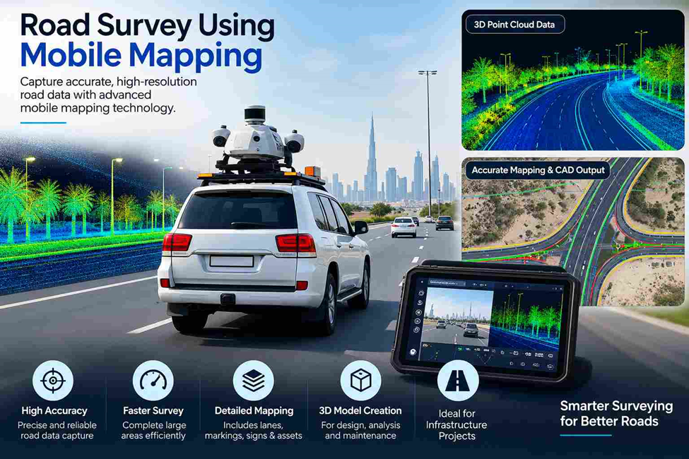
Road surveys become more demanding as the length and complexity of a project increase. A short road section can be measured using conventional survey equipment, but long corridors, busy streets, junctions and existing infrastructure can require a different approach.
Mobile mapping helps survey teams collect road data while moving through the corridor. Instead of stopping at every measurement location, a mobile mapping system captures a continuous stream of spatial information using technologies such as LiDAR, GNSS/INS and imaging sensors.
For Dubai road projects, this approach can be useful when a survey needs to cover a large corridor while recording the road surface, surrounding features and existing assets in a consistent dataset.
What Is a Road Survey?
A Road Survey measures and documents the physical conditions of a road corridor for planning, design, construction, rehabilitation, and verification. It can capture road edges, centreline, levels, gradients, kerbs, junctions, drainage, footpaths, utilities, signs, and existing structures. The survey scope depends on the specific requirements of the engineering or construction project.
How Mobile Mapping Changes the Survey Approach
Traditional road surveying often involves moving between measurement points, setting up instruments and recording individual observations. This remains useful when specific points require high precision.
Mobile mapping takes a different approach.
The survey system moves through the road corridor while its sensors continuously collect spatial information. GNSS and inertial measurement systems help determine the position and movement of the mapping platform, while LiDAR and cameras capture the surrounding environment.
The result is a dense dataset that can represent a long section of road rather than a collection of isolated measurements.
This is particularly useful for linear infrastructure because the survey team can collect information continuously along the route.
What Can Be Captured During a Mobile Road Survey?
A mobile mapping survey can capture much more than the road surface itself.
Depending on the equipment, project specifications and required accuracy, the collected data may be used to identify:
Road geometry
Road edges, lane arrangements, medians, junction layouts and other visible geometric features can be extracted from the survey dataset.
Levels and surface information
The point cloud can provide detailed information about the surveyed surface. Surveyors can use the data to examine changes in elevation, slopes and road profiles.
Roadside assets
Visible signs, barriers, poles, lighting columns, bollards and other roadside objects can be recorded as part of the mapped environment.
Surrounding features
Buildings, walls, entrances, footpaths and other features close to the road can also be represented where they fall within the survey coverage.
Visual records
Where imaging is included, photographs or panoramic imagery can provide an additional reference when reviewing the surveyed corridor.
The important point is that mobile mapping produces a spatial record of the corridor. The final survey information should still be checked against the project requirements before it is used for engineering decisions.
A Typical Mobile Mapping Workflow for Road Surveys
A road survey using mobile mapping usually starts before the mapping vehicle enters the site.
1. Define the survey corridor
The survey team first identifies the road limits, junctions, connecting routes and surrounding areas that need to be captured.
This prevents gaps in coverage and helps determine the most suitable survey route.
2. Establish survey control
Reliable positioning is essential. Control points or other reference information may be established so that the mobile mapping data can be related to the required coordinate system.
This stage is especially important when the survey needs to be combined with existing engineering drawings or other survey datasets.
3. Capture the corridor
The mobile mapping platform travels through the road network while its sensors collect spatial and visual data.
Unlike a survey based entirely on individual occupied points, the system records information continuously as it moves.
4. Process and register the data
The collected observations are processed into a usable spatial dataset. Point-cloud data, imagery and positioning information are brought together and checked for consistency.
Unwanted data may need to be removed before the dataset is used for mapping or extraction.
5. Extract the required road information
The survey team then extracts the information required for the project. Depending on the scope, this can include road features, levels, profiles, alignment information and mapped assets.
6. Check the final survey
The finished dataset should be reviewed against survey control and project specifications. Additional field checks may be required for critical points where a higher level of confidence is needed.
This final check is important because a large dataset is not automatically an accurate engineering survey.
Mobile Mapping vs Conventional Road Surveying
Mobile mapping should not be viewed as a complete replacement for conventional surveying.
A total station or GNSS receiver may still be the better choice for specific points requiring controlled, high-precision measurement. Mobile mapping is more useful when the priority is continuous coverage and efficient collection across a large corridor.
In practice, combining methods can produce a stronger result.
For example, mobile mapping can be used to capture the wider road corridor, while survey control and selected critical points can be checked using conventional survey equipment.
The right combination depends on the required accuracy, project size, site conditions and final deliverables.
Accuracy Considerations for Mobile Road Surveys
Speed and coverage are major advantages of mobile mapping, but accuracy still depends on how the survey is planned and executed.
Several factors matter:
GNSS conditions: Satellite visibility and positioning quality can affect the trajectory of the mapping system.
Inertial navigation: The system’s movement and orientation need to be properly managed, particularly where satellite signals are interrupted.
Survey control: Reliable control provides an independent reference for checking the mobile mapping results.
Sensor calibration: LiDAR, cameras and positioning sensors need to work together correctly.
Point-cloud quality: Occlusions, moving vehicles and environmental conditions can affect what is captured.
Independent checks: Important locations should be verified where the project specification requires additional confirmation.
For this reason, the question should not simply be whether mobile mapping is “accurate.” The better question is whether the survey workflow, equipment, control and quality checks are suitable for the accuracy required by the project
Final Thoughts
Mobile mapping is useful for surveying long road corridors by capturing continuous spatial data while reducing the need for frequent stops and individual setups. It is not suitable for every measurement, but it can improve field efficiency where extensive corridor coverage and detailed spatial data are required. For Dubai projects, the method should be selected based on the corridor, accuracy, control requirements, and required deliverables.
Need Road Survey Support in Dubai?
Northern Engineering Surveys L.L.C. provides road and engineering surveying support in Dubai and across the UAE. Our survey capabilities include mobile mapping, GPS/GNSS surveying, topographic surveys, 3D laser scanning and other land surveying services.
For a road corridor or infrastructure project, the survey method can be planned around the required coverage, accuracy and deliverables.
Contact Northern Engineering Surveys L.L.C. to discuss your road survey requirements.
Frequently Asked Questions
1. What is mobile mapping in road surveying?
Mobile mapping is a survey method in which a moving platform collects spatial data using sensors such as LiDAR, GNSS/INS and cameras. It is particularly useful for surveying long roads and infrastructure corridors.
2. Can mobile mapping be used for road alignment surveys?
Yes. Mobile mapping can capture the geometry and surrounding features of a road corridor. The processed data can then be used to extract alignment-related information, profiles and other survey details required by the project.
3. Is mobile mapping suitable for large road corridors?
Yes. Its ability to collect data while moving makes it well suited to long corridors where surveying every feature individually would take considerable field time.
4. Does mobile mapping replace total station surveying?
Not always. Total stations remain useful for controlled measurements and specific high-precision points. Mobile mapping and conventional surveying can be combined when a project needs both broad corridor coverage and detailed verification.
5. What data can be delivered from a mobile road survey?
Depending on the project scope, deliverables may include point clouds, CAD drawings, road plans, profiles, cross sections, mapped assets, georeferenced imagery and GIS-compatible data.
6. How is the accuracy of a mobile mapping road survey checked?
Accuracy can be assessed using survey control, positioning checks, sensor calibration and independent field measurements at selected locations. The exact checking procedure should be based on the project’s required accuracy and specifications.