
3D Laser Scanning for Floor Flatness and Levelness in Construction
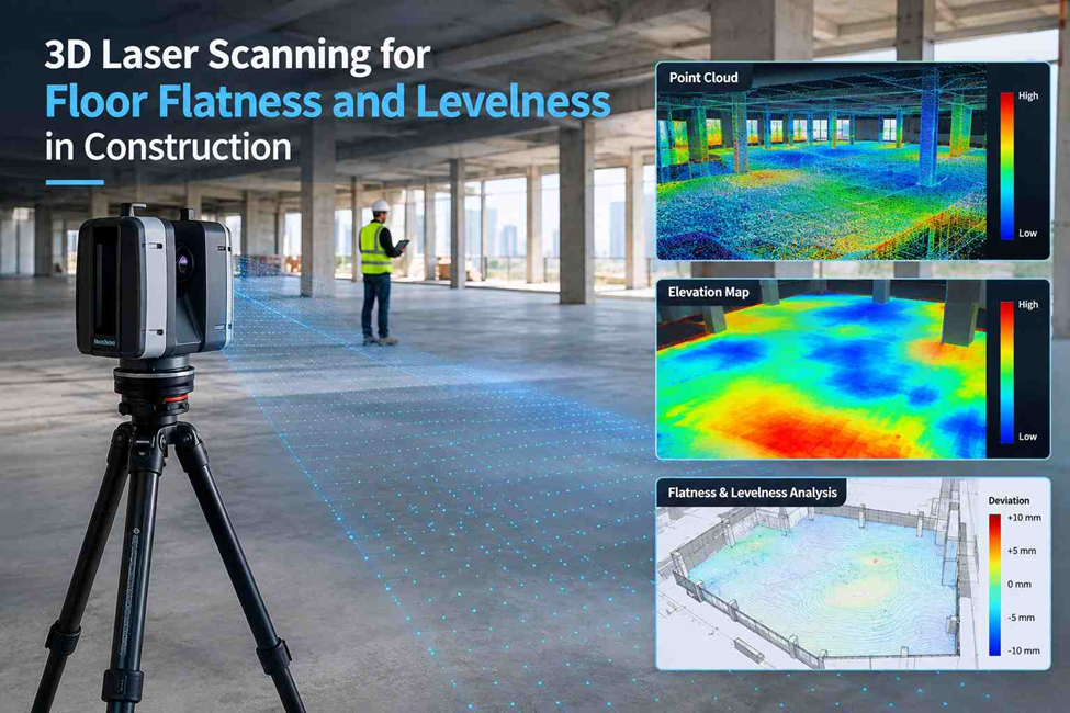
A finished floor can look level to the eye and still have noticeable changes in elevation across its surface. On a construction site, even small variations can create problems when machinery, partitions, flooring systems, doors, or other components need to fit accurately.
This is where 3D laser scanning for floor flatness and levelness can provide detailed surface information. Instead of checking only a few individual points, a laser scanner captures thousands of measurements across the floor and produces a dense 3D representation of the surveyed area.
The resulting point cloud can then be used to examine floor elevations, surface variations, slopes, and local deviations.
What Are Floor Flatness and Floor Levelness?
- Floor flatness and floor levelness describe two different characteristics of a finished or partially finished floor.
- Floor flatness relates to how much the surface changes over a short distance. It is concerned with local bumps, dips, and uneven areas.
- Floor levelness looks at the overall elevation of the floor and how it varies across a larger area.
- A floor may therefore be relatively smooth but still have a gradual slope. Another floor may have the correct general elevation but contain local high and low spots.
- For construction teams, both conditions can matter depending on how the space will be used.
Why Floor Surface Accuracy Matters on Construction Sites
Floor elevation becomes important when several building elements have to meet within tight tolerances.
Common examples include:
- Industrial floors supporting equipment or machinery
- Warehouse floors used by material-handling systems
- Concrete slabs before floor finishes are installed
- Commercial spaces requiring accurate finished levels
- Large open floors where local variations are difficult to see
- Areas where doors, partitions, ramps, or other components depend on finished elevations
A small difference may not matter in one area but can become significant across a large floor.
Early measurement gives the project team actual site data instead of relying only on visual inspection.
How 3D Laser Scanning Measures a Floor
A 3D laser scanner sends laser measurements toward the surrounding surface and records the position of each measured point.
When the scanner is moved through different positions on the site, these measurements can be combined into a single point cloud.
For a floor survey, the workflow generally includes:
- Establish survey control
Known control points are used to provide a consistent coordinate reference for the scan.
- Set up the scanner
Scanner positions are selected so that the required floor area can be captured with sufficient coverage.
- Capture the floor surface
The scanner records a large number of points across the concrete or finished floor.
- Register the scans
Multiple scan positions are combined into one coordinated point cloud.
- Clean and prepare the data
Unwanted objects and irrelevant points can be removed before analysis.
- Create a floor surface
The relevant floor points can be processed into a surface or elevation model.
- Check elevation variations
The surface is examined for high points, low points, slopes, and other measurable deviations.
- Prepare the required deliverables
Depending on the project, the survey information can be provided through point clouds, CAD drawings, surface models, colour maps, or reports.
What Can a Floor Scan Show?
A detailed scan can provide considerably more information than a small set of manual measurements.
Depending on the survey requirements, the data can be used to identify:
- High and low areas
- Changes in floor elevation
- Local surface irregularities
- General floor slope
- Differences between surveyed areas
- Changes across concrete slabs
- Areas requiring closer inspection
- Floor geometry compared with design information
A colour-coded elevation map can also make variations easier to understand. Different elevation ranges can be displayed with different colours, allowing site and engineering teams to identify areas that need attention without studying individual point coordinates.
Floor Levelness Survey for Large Areas
Levelness becomes particularly important on large floor plates where a gradual change in elevation may not be obvious from ground level.
A floor levelness survey can compare elevations across the surveyed area and show how the floor changes from one location to another.
This can be useful for:
- Warehouses
- Factories
- Distribution centres
- Parking structures
- Large commercial buildings
- Industrial facilities
- Large concrete slabs
For these projects, a digital survey provides a clearer picture of the floor than relying only on visual inspection.
When Should a Floor Be Scanned?
The timing depends on what the project needs to verify.
Before floor finishes
Scanning the concrete slab can provide a record of the underlying surface before additional layers are installed.
During construction
Periodic surveys can be used to check selected areas as construction progresses.
Before equipment installation
Industrial or commercial projects may require floor information before equipment, machinery, racks, or other systems are installed.
After completion
A final scan can document the completed condition and provide a digital record for project documentation.
What Deliverables Can Be Produced?
The required output depends on the project and how the information will be used.
Typical deliverables may include:
- Registered 3D point clouds
- Floor elevation maps
- Colour-coded deviation maps
- Surface models
- Contour information
- CAD drawings
- Elevation data
- Sections and profiles
- Digital survey reports
- Comparison drawings
- BIM-compatible data where required
For projects that require broader spatial documentation, the survey can also be integrated with other 3D laser scanning services and existing survey control.
Can 3D Laser Scanning Replace a Floor Flatness Test?
Not automatically.
- A laser scan provides detailed geometric information about the surveyed surface, but a project’s formal floor testing requirements may depend on the applicable specification, standard, testing method, and acceptance criteria.
- For this reason, the scanning survey should be planned around the project’s actual requirements.
- Where a formal compliance test is required, the scan should be treated as a surveying and measurement tool that supports the project process rather than assuming it replaces the specified test.
What Affects the Accuracy of a Floor Scan?
Several factors influence the quality of the final survey.
Scanner capability
The scanner must be suitable for the required measurement range, point density, and accuracy.
Survey control
Reliable control helps maintain the correct coordinate reference and improves registration consistency.
Scanner setup
Poor positioning or insufficient overlap between scans can affect registration and coverage.
Surface conditions
Dust, reflective materials, standing water, obstructions, and other site conditions can affect data capture.
Registration quality
Individual scans need to be correctly aligned before the complete point cloud is analysed.
Processing method
Filtering, surface generation, coordinate transformation, and comparison settings can influence the final results.
For this reason, floor scanning should be planned around the required accuracy rather than simply collecting the maximum possible amount of data.
Why Use 3D Laser Scanning for Floor Surveys?
For suitable construction projects, the main advantage is the amount of spatial information captured in one survey.
It can provide:
- Dense measurement coverage
- Faster collection across large areas
- A digital record of the surveyed condition
- Easier identification of elevation changes
- Data that can be reviewed during office processing
- Integration with CAD and other digital workflows
- Useful information for construction verification
The value comes from turning the physical floor into measurable digital data that can be checked, compared, and documented.
Need Accurate Floor Survey Data?
When floor flatness, levelness, and elevation need to be checked accurately, 3D laser scanning provides detailed survey data across the entire accessible surface. Northern Engineering Surveys L.L.C. can capture floor conditions, process the scan data, and provide clear survey outputs for construction verification, quality control, and project documentation. Whether you are checking a concrete slab before finishing work or verifying an existing floor against design information, our surveying team can support the measurement and documentation required for your project in Dubai.
Contact Northern Engineering Surveys L.L.C. for 3D laser scanning and floor survey services.
FAQs
1. What is 3D laser scanning for floor flatness?
3D laser scanning for floor flatness captures a dense set of measurements across a floor surface and processes them into a point cloud or surface model. The data can then be analysed to identify local elevation changes and surface variations.
2. Can 3D laser scanning measure floor levelness?
Yes. A registered point cloud can be used to examine floor elevations across a surveyed area and identify gradual changes, slopes, high areas, and low areas.
3. Is 3D laser scanning suitable for concrete floor surveys?
Yes. It can be used to capture concrete slabs and other accessible floor surfaces where detailed elevation and geometry information is required.
4. What information is included in a floor laser scanning survey?
Depending on the project scope, the survey may provide registered point clouds, floor elevation maps, surface models, colour-coded maps, CAD data, sections, profiles, and survey reports.
5. Can a laser scan compare an existing floor with the design?
Yes, when suitable design information and a compatible coordinate reference are available. The surveyed surface can be compared with the design to identify areas where the constructed geometry differs from the intended condition.
6. Does 3D laser scanning replace a formal floor flatness test?
Not necessarily. The required testing method depends on the project specification and applicable standard. Laser scanning can provide detailed geometric data, but it should not automatically be considered a replacement for a specified compliance test.