

Before a villa foundation is set out, a road alignment is established, or a pipeline trench is excavated, survey data has to define where the work belongs on the ground.
That means establishing boundaries, measuring existing levels, fixing control, locating utilities, setting out design coordinates, or recording completed construction. The survey required depends on the type of project and the decisions the design and construction teams need to make from the data.
A villa site, for example, may need boundary and topographic information before setting-out begins. A pipeline project may need route surveying and underground utility detection. A port development may require hydrographic measurements below the waterline.
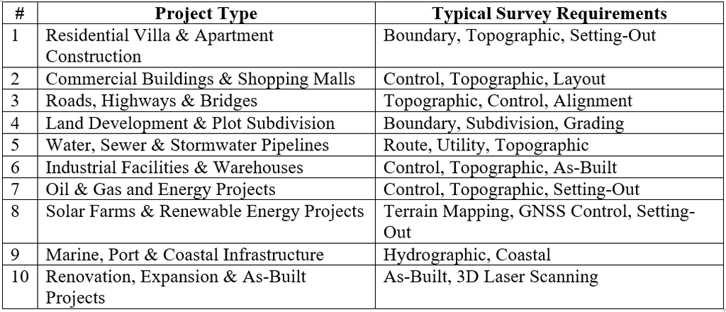
Here are ten UAE construction and infrastructure project types where professional surveying plays a direct role.
1. Residential Villa and Apartment Construction
Typical survey requirements: Boundary Survey, Topographic Survey, Setting-Out Survey
Residential construction normally starts with establishing the plot and understanding the existing ground conditions.
A boundary survey identifies the surveyed limits of the property. A topographic survey records existing elevations and visible site features. Once the design is approved, setting-out transfers building coordinates, gridlines and other design positions onto the site.
This information helps the construction team position the building correctly in relation to the surveyed plot, site levels and approved design.
2. Commercial Buildings and Shopping Malls
Typical survey requirements: Control Survey, Topographic Survey, Layout Survey
Large commercial projects require a reliable survey control framework because construction involves many coordinates, levels and structural elements across a relatively large footprint.
Survey teams may establish horizontal and vertical control, capture existing terrain and site features, and provide layout information for foundations, columns, grids, roads and external works.
As construction progresses, additional setting-out and as-built measurements can be used to verify that installed elements correspond with the design coordinates and levels.
3. Roads, Highways and Bridges
Typical survey requirements: Topographic Survey, Control Survey, Alignment Survey
Road and bridge projects depend heavily on accurate terrain, alignment and elevation information.
Topographic surveys capture the existing ground, kerbs, drainage features, structures, road edges and other relevant site details. Alignment surveys establish the horizontal and vertical geometry needed for road or corridor design.
Survey data can also support:
- road centreline establishment
- profile and cross-section preparation
- earthwork calculations
- drainage design
- bridge positioning
- construction setting-out
- as-built verification
For long road corridors, maintaining consistent control along the project is particularly important because small coordinate or level errors can propagate over distance.
4. Land Development and Plot Subdivision
Typical survey requirements: Boundary Survey, Subdivision Survey, Grading Survey
Before a large parcel becomes a residential, commercial or mixed-use development, the existing land has to be defined accurately.
Survey work can establish property boundaries, existing levels, site features and subdivision geometry. Grading information is then used to understand how the proposed development will sit within the existing terrain.
Survey data may support the positioning of:
- individual plots
- internal roads
- drainage networks
- utility corridors
- landscape areas
- access routes
The survey therefore becomes part of the spatial framework used to coordinate the wider development.
5. Water, Sewer and Stormwater Pipeline Projects
Typical survey requirements: Route Survey, Utility Survey, Topographic Survey
Pipeline construction has a different survey problem from a building site. The work extends along a route, often through areas containing existing roads, utilities and other infrastructure.
Route surveys establish the corridor and existing ground conditions. Utility surveys help identify and map existing underground services before excavation.
Depending on the project scope, the survey may include:
- pipeline alignment
- existing utility locations
- invert and cover levels
- manholes and chambers
- road crossings
- drainage structures
- corridor topography
- construction setting-out
Combining surface survey information with underground utility mapping gives the design and construction teams a clearer picture of the corridor before excavation begins.
6. Industrial Facilities and Warehouses
Typical survey requirements: Control Survey, Topographic Survey, As-Built Survey
Industrial facilities often contain large buildings, hardstand areas, equipment foundations, access roads, drainage networks and service corridors.
Survey control provides the coordinate framework for construction. Topographic data records existing site conditions, while setting-out transfers the design positions of foundations, structures and external works.
After installation, as-built surveying can record the actual position and elevation of completed elements. This becomes particularly useful when the facility will later be extended, modified or coordinated with new engineering work.
7. Oil and Gas and Energy Projects
Typical survey requirements: High-Precision Control Survey, Topographic Survey, Setting-Out Survey
Oil and gas facilities, substations, transmission infrastructure and other energy projects often involve tightly controlled construction coordinates and defined survey tolerances.
Survey work may cover:
- primary and secondary control
- equipment foundations
- pipe racks
- access corridors
- cable routes
- structural elements
- existing utilities
- plant modifications
- as-built verification
The required accuracy should be established from the project’s specifications rather than assumed to be the same for every energy project. Control procedures, equipment selection and verification methods should be matched to the required construction tolerance.
8. Solar Farms and Renewable Energy Projects
Typical survey requirements: Terrain Mapping, GNSS Control, Setting-Out Survey
Large solar installations cover substantial areas, so understanding the existing terrain is important before grading, access-road construction and array installation begin.
Survey data can be used for:
- terrain and elevation mapping
- site grading
- solar array positioning
- pile or foundation setting-out
- inverter and substation locations
- internal access roads
- drainage planning
- construction verification
GNSS-based control and conventional survey equipment may be used together depending on the required accuracy, site conditions and construction stage.
For large sites, survey data also provides a common spatial reference for coordinating the civil, structural and electrical components of the project.
9. Marine, Port and Coastal Infrastructure
Typical survey requirements: Hydrographic Survey, Coastal Survey
Ports, marinas, seawalls, waterfront developments and dredging projects require measurements that extend beyond the land boundary.
Hydrographic surveying captures underwater depths and seabed information. Depending on the project, this may be combined with topographic and coastal surveys to create a continuous understanding of the interface between land and water.
Survey information can support:
- bathymetric mapping
- dredging quantities
- seabed profiling
- quay and berth works
- seawall construction
- marine structure positioning
- coastal development
- underwater condition surveys
The equipment and survey method depend on water depth, required accuracy, project scale and the type of marine work being undertaken.
10. Renovation, Expansion and As-Built Projects
Typical survey requirements: As-Built Survey, 3D Laser Scanning
Existing buildings rarely match their original drawings perfectly after years of construction changes, alterations and installations.
Before a renovation or extension, an as-built survey establishes the conditions that actually exist. 3D laser scanning can capture walls, floors, ceilings, structural elements and MEP services as dense spatial data.
The resulting point cloud can then be used to produce:
- 2D CAD drawings
- floor plans
- elevations
- sections
- 3D models
- BIM models
- MEP coordination data
This gives the design team measured existing conditions rather than relying entirely on drawings that may no longer represent the building accurately.
Choosing the Survey Type for the Project
The project itself usually determines the survey scope.
New building on an undeveloped plot:
Boundary + topographic + control + setting-out
Road or infrastructure corridor:
Topographic + control + alignment + utility survey where required
Pipeline construction:
Route + topographic + underground utility mapping
Large land development:
Boundary + topographic + grading + subdivision
Industrial construction:
Control + topographic + setting-out + as-built
Existing building renovation:
As-built + 3D laser scanning + CAD/BIM modelling
Port or marine development:
Hydrographic + coastal/topographic survey
There is no single survey package that fits every project. The survey scope should be based on the design stage, site conditions, construction requirements and final deliverables.
Why Survey Scope Matters
Choosing the right survey is not simply about collecting more points.
A boundary survey answers a different question from a topographic survey. A utility survey addresses information that cannot be obtained from surface levels alone. A setting-out survey transfers design coordinates to the construction site, while an as-built survey records what was actually constructed.
The useful question is therefore not:
“Do we need a land survey?”
It is:
“What information does the project need from the site, and what survey method will provide it at the required accuracy?”
That distinction matters when preparing designs, coordinating infrastructure, setting out construction and producing approval or handover documentation.
Surveying Support for UAE Construction Projects
Northern Engineering Surveys L.L.C. provides surveying support for construction and infrastructure projects across Dubai and the UAE, including topographical surveys, GPS/GNSS surveying, gate level computation and other land surveying requirements.
If you are unsure which survey is appropriate for your project, the starting point is to define the site, project stage, required accuracy and intended deliverables. From there, the survey scope can be matched to the actual construction requirement.
Contact the survey team to discuss the survey requirements for your project.