
Photogrammetry vs 3D Laser Scanning: Accuracy, Data and Applications
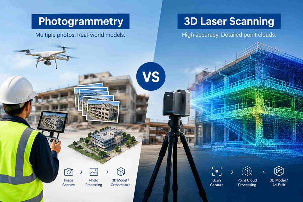
When a construction project needs reliable 3D measurements, choosing the right survey method can affect the quality of the final drawings, models and site records. Photogrammetry and 3D laser scanning can both capture existing conditions, but they collect information in different ways.
Photogrammetry uses overlapping photographs to calculate the position and shape of visible features. 3D laser scanning measures distances using laser light and builds a three-dimensional representation from the captured points. Each method has its own strengths, and the right choice depends on the site, the required level of detail, the available access and the final deliverables.
For contractors, consultants, architects and developers, understanding these differences helps when planning a survey and deciding what information the project team needs.
What Is Photogrammetry in 3D Surveying?
Photogrammetry uses photographs taken from different angles to create 3D models of objects, surfaces and terrain. Specialised software processes overlapping images to generate:
- 3D point clouds
- Textured 3D models
- Orthophotos and orthomosaics
- Digital surface models
- Topographic mapping data
In surveying, drone photogrammetry helps map construction sites, stockpiles and terrain efficiently. Accuracy depends on image quality, overlap, lighting and survey control. Shadows, reflective surfaces and hidden areas can affect the results.
How 3D Laser Scanning Captures Spatial Data
3D laser scanning records the position of surfaces by measuring the distance between the scanner and the objects around it. Depending on the equipment, the scanner uses laser pulses or phase measurements to calculate distances and build a set of three-dimensional coordinates.
Each measured point forms part of a point cloud. When several scans are collected from suitable positions and aligned, the combined dataset can represent walls, columns, beams, ceilings, floors, structural elements and other visible surfaces.
For building and construction surveys, the data can be used to examine dimensions, check clearances, measure surface positions and prepare digital representations of existing conditions.
The quality of a laser scanning survey depends on more than the scanner’s specifications. Scan positions, instrument calibration, survey control, surface reflectivity, obstructions and the registration process all influence the final result. Areas hidden behind equipment or structural elements may require additional scan positions to capture the missing geometry.
Unlike photogrammetry, laser scanning does not rely on matching image features to calculate the primary surface measurements. This makes it useful for capturing geometric information on surfaces with limited visual texture, provided the scanner can obtain suitable returns.
Photogrammetry vs Laser Scanning: Key Technical Differences
The main difference is how the two methods obtain three-dimensional information. Photogrammetry derives geometry from overlapping images, while laser scanning measures distances directly to visible surfaces.
| Comparison factor | Photogrammetry | 3D laser scanning |
| Data capture | Overlapping photographs | Laser distance measurements |
| Main output | 3D models, point clouds and textured surfaces | 3D point clouds and measured surface geometry |
| Visual information | Rich colour and image texture | Geometry, with colour available on systems equipped for image capture |
| Surface requirements | Benefits from visible features and image texture | Can capture surfaces without distinctive image patterns |
| Common platforms | Drones, cameras and aerial imaging systems | Terrestrial scanners, mobile systems and airborne LiDAR |
| Main limitations | Shadows, reflective surfaces, weak texture and occlusion | Occlusion, limited line of sight, reflectivity and scan positioning |
| Typical applications | Large-area mapping, terrain models and textured models | Detailed building measurements, structural geometry and complex spaces |
Neither method is automatically more accurate in every situation. A carefully controlled photogrammetry survey can produce reliable measurements, while a poorly planned laser scanning survey can contain gaps or alignment errors. The equipment, survey design, control and processing workflow all matter.
Point Cloud Density, Surface Detail and Measurement Accuracy
Point density describes how closely measured points are spaced across a surface. It affects how much geometric detail can be represented, but a dense point cloud is not necessarily an accurate one.
For example, a building facade may appear highly detailed in a 3D model, yet the measurements could be offset if the survey control or image alignment is incorrect. The same issue applies to laser scanning: millions of measured points do not remove systematic errors or incorrect registration.
When assessing survey data, project teams should consider three separate factors:
- Point density: Whether the dataset contains enough points to represent the required features.
- Spatial accuracy: How closely the measured coordinates match the actual positions of the surveyed features.
- Completeness: Whether important surfaces and areas have been captured without significant gaps.
Photogrammetry can produce detailed surface geometry when photographs have suitable overlap, sharp focus, sufficient texture and reliable control. Laser scanning can capture dense geometric information, particularly where close-range measurement of structural details is needed.
For both methods, independent check points, known dimensions and suitable quality-control procedures help establish whether the data meets the project specification. Accuracy should be verified against the required tolerance rather than assumed from the equipment type alone.
Photogrammetry and Laser Scanning for Building Surveys
The choice between photogrammetry and laser scanning often comes down to the parts of the building that need to be measured and the information required by the design team.
Photogrammetry can be useful when the project requires a visual record of external surfaces, roofs, facades or large accessible areas. Images provide colour and texture that can help teams identify visible materials, surface conditions and architectural features.
3D laser scanning is often suitable when detailed measurements of existing geometry are required. It can capture the arrangement of columns, beams, walls, ceilings and structural connections for subsequent analysis or design coordination.
Consider a refurbishment project in which the contractor needs to document an existing commercial building before modifying its internal layout. Laser scanning may be selected to capture the geometry of rooms, corridors, structural elements and service areas. Photogrammetry may be added where textured facade models or visual records of external surfaces are also required.
The survey specification should define the intended outputs, such as measured plans, elevations, sections, point clouds or 3D models. It should also identify the necessary tolerances, coordinate reference system and areas that must be covered.
A method should be selected according to those requirements, not simply because one technology is newer or produces a more visually impressive model.
Choosing Between Photogrammetry and Laser Scanning for Infrastructure Projects
Infrastructure surveys can cover roads, bridges, earthworks, retaining structures, drainage assets and other large installations. The appropriate capture method depends on the size of the area, access restrictions, surface characteristics and required level of detail.
Photogrammetry is often practical for mapping broad areas where image coverage can be planned efficiently. Drone imagery, for example, can help create orthophotos, surface models and terrain-related datasets for site assessment and planning.
Laser scanning can be useful for capturing bridge components, structural surfaces, confined sections and other features where detailed three-dimensional geometry is important. Mobile or airborne LiDAR may be considered for suitable corridor and large-area surveys.
Before selecting either method, the survey team should assess:
- The dimensions and shape of the survey area.
- Whether the required surfaces are visible from the planned capture positions.
- The accuracy and point-density requirements.
- Traffic, access, safety and operational restrictions.
- The coordinate control and verification procedures.
- The formats needed by engineers, designers and contractors.
For infrastructure projects, a combination of methods may be more appropriate than relying on a single dataset. Aerial photogrammetry can provide broad visual coverage, while targeted laser scanning can capture areas that need more detailed geometric measurements.
Combining Photogrammetry and 3D Laser Scanning for Survey Data Integration
Using both technologies can provide a more complete record when the project needs broad site coverage as well as detailed measurements of selected structures.
For example, photogrammetry may be used to map a construction site and its surrounding terrain. Laser scanning can then capture the geometry of a building, bridge element or other structure requiring closer inspection. The resulting datasets can be brought into a common coordinate system for comparison and further processing.
However, combining datasets requires careful planning. The survey team needs to check coordinate references, scale, control points, registration quality and the differences between the captured surfaces. Image-derived and laser-derived point clouds may not align perfectly, even when they represent the same physical feature.
A reliable integration workflow generally involves:
- Establishing the project coordinate system and survey control.
- Capturing photographs and laser measurements with suitable coverage.
- Processing each dataset using the appropriate software.
- Registering the outputs to a common reference.
- Checking alignment against independent control or known measurements.
- Reviewing gaps, inconsistencies and areas that require additional capture.
The combined data can support detailed site records, engineering analysis and 3D visualisation. The final deliverables should still be checked against the project’s measurement requirements before being used for design or construction decisions.
Limitations of Photogrammetry and Laser Scanning in Complex Site Conditions
Both methods depend on having a suitable view of the surfaces being surveyed. Neither can reliably document a feature that is completely hidden from the capture system.
Photogrammetry can struggle with plain, reflective or transparent surfaces because the software may not find enough consistent image features. Strong shadows, changing lighting and blurred photographs can also affect reconstruction.
Laser scanning can encounter difficulties with glass, highly reflective materials, dark surfaces and narrow spaces where the scanner cannot obtain sufficient returns. Structural elements, machinery and temporary site installations can block the laser’s line of sight.
Other practical issues include:
- Restricted access: Some areas may require additional setups or a different capture method.
- Movement: Vehicles, workers or moving equipment can introduce inconsistencies into the captured data.
- Processing requirements: Large datasets require appropriate computing resources, storage and quality checks.
- Survey control: Poor control or incorrect coordinate transformations can affect the position of the final model.
- Incomplete coverage: Hidden surfaces may need additional images, scan positions or supplementary measurements.
These limitations should be assessed during survey planning. Identifying difficult areas before data capture can reduce the need for repeat visits and help ensure the final dataset is suitable for its intended use.
How to Select the Right 3D Survey Method for Your Project
Start by defining what the project team needs to measure. A survey intended to produce a textured model of a large site has different requirements from one intended to document structural clearances inside an existing building.
Photogrammetry may be the better fit when broad visual coverage, surface texture and large-area mapping are priorities. Laser scanning may be more appropriate when detailed surface geometry and dimensional records are required. When both types of information are important, a combined workflow may be worth considering.
Before appointing a survey provider, confirm the following:
- What areas and features will be captured?
- What positional accuracy and measurement tolerances are required?
- Which coordinate system and survey-control method will be used?
- What deliverables will be supplied, and in which file formats?
- How will data completeness and accuracy be checked?
- Are additional measurements needed for hidden or inaccessible areas?
These questions help establish a clear scope and make it easier to assess whether the proposed survey method meets the requirements of the project.
Need 3D Survey Data for Your Project?
Northern Engineering Surveys L.L.C. provides surveying and mapping services for construction, building and infrastructure projects. Selecting the appropriate capture method begins with understanding the site conditions, measurement requirements and information the project team needs.
For projects requiring existing-condition measurements, surface mapping or detailed spatial data, NES Dubai can help assess the suitable survey approach and required deliverables.
Visit https://nesdubai.com/ or contact the team at info@nesdubai.com or +971 50 255 8005 to discuss your survey requirements.
Frequently Asked Questions
1. What is the main difference between photogrammetry and 3D laser scanning?
Photogrammetry uses overlapping photographs to calculate three-dimensional geometry. 3D laser scanning measures distances to visible surfaces and records their spatial coordinates. Both can produce point clouds and 3D models, but their suitability depends on the project requirements and capture conditions.
2. Is photogrammetry more accurate than laser scanning?
Not necessarily. Accuracy depends on equipment, image or scan quality, survey control, processing and verification. Both methods can produce reliable results when the workflow is designed to meet the required measurement tolerances.
3. Can photogrammetry produce a point cloud?
Yes. Photogrammetry software can reconstruct a three-dimensional point cloud from overlapping images. The resulting dataset can be used for surface modelling, mapping and other applications where its accuracy and completeness meet the project requirements.
4. When should a construction project use 3D laser scanning?
Laser scanning is useful when detailed measurements of existing structures, building interiors, structural elements or complex spaces are needed. It can provide a dense geometric record for measurement, design coordination and other engineering tasks.
5. Can photogrammetry and laser scanning be used together?
Yes. The two methods can complement each other when a project needs broad image-based coverage and detailed geometric measurements. The datasets must be aligned to a common coordinate reference and checked for accuracy and consistency.
6. What affects the accuracy of a 3D laser scanning survey?
Accuracy can be affected by instrument calibration, scan distance, surface characteristics, scan positioning, survey control, registration and environmental conditions. Independent checks against known measurements help establish whether the final data meets the project specification.