
How Contour Surveys Support Site Grading and Topographic Design
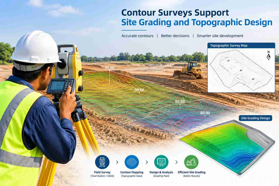
Before grading a construction site, engineers need accurate information about how the ground rises, falls, and changes. A contour survey provides this elevation data, helping teams plan site levels, slopes, drainage, and earthwork more effectively.
For buildings, roads, landscaping, and infrastructure, reliable ground-level information helps create practical designs and avoid problems during construction.
What Is a Contour Survey?
A contour survey records the elevation of the ground and represents areas with similar elevations through contour lines. These lines help surveyors, engineers, and designers understand the shape of the existing terrain.
Closely spaced contours generally indicate a steeper change in elevation, while wider spacing usually indicates a gentler slope.
A contour survey may also include spot levels and other surveyed points where specific elevations are important. Together, these measurements provide a clearer picture of the existing ground surface.
Why Contour Information Matters Before Site Grading
Site grading is not simply about making a piece of land flat. The finished surface needs to work with the proposed building, access roads, drainage system, surrounding levels, and other site features.
A grading design therefore needs a reliable starting point.
Contour survey data provides the existing ground levels needed to establish that starting point. The design team can compare the existing terrain with proposed levels and determine where changes to the ground surface are required.
This can help identify:
- High and low areas across the site
- Existing slopes and changes in terrain
- Areas requiring excavation
- Areas requiring filling
- Potential drainage paths
- Differences between the site and adjoining properties
- Existing levels around roads and access points
- Areas where retaining structures may be required
How Contour Surveys Support Site Grading
1. Establishing Existing Ground Levels
The first step in a grading design is understanding the existing surface.
A contour survey gives the design team measured elevation information across the site. This allows existing ground conditions to be represented more accurately than relying on isolated measurements or visual observations.
For a large or uneven site, this information becomes particularly useful because elevation can change considerably from one part of the property to another.
2. Identifying Natural Slopes
The direction and steepness of the existing terrain influence how the site can be developed.
Contour patterns help show where the land naturally rises or falls. Engineers can use this information when planning building platforms, roads, pedestrian routes, drainage and landscaped areas.
Working with the existing terrain where practical can also reduce unnecessary earthwork.
3. Planning Cut and Fill Areas
Once existing and proposed levels are available, the difference between them can be assessed.
Areas where the existing ground is above the proposed level may require excavation or cut. Areas below the proposed level may require fill.
A reliable contour survey helps establish these differences across the site and provides useful information for estimating earthwork requirements.
4. Supporting Drainage Design
Water movement is closely connected to ground levels.
A grading plan needs to direct surface water away from buildings and toward suitable drainage points without creating unwanted low spots or conflicts with surrounding levels.
Contour information helps designers understand the existing fall of the land and develop appropriate proposed slopes.
This is particularly important where drainage routes, roads, paved areas, and building entrances need to connect at controlled levels.
5. Setting Building Platforms
Buildings often require a carefully controlled finished floor level.
The proposed building platform needs to be considered in relation to the surrounding ground, access roads, drainage, parking areas, and neighbouring properties.
Contour survey data helps the design team compare the proposed building level with the existing terrain and identify the grading work needed around the structure.
Contour Survey and Topographic Design
Contour surveying is closely connected with topographic surveying because both contribute to understanding the physical characteristics of a site.
A topographic survey can capture features such as:
- Ground elevations
- Existing structures
- Roads and kerbs
- Drainage features
- Walls and fences
- Utilities and visible service features
- Trees and other site features
- Changes in terrain
Contour information can then be used to represent the elevation component of the site.
For design teams, combining terrain information with existing physical features provides a more useful representation of the site for planning and engineering work.
Contour Intervals and Site Interpretation
The contour interval is the difference in elevation between two consecutive contour lines.
The appropriate interval depends on factors such as the size of the site, terrain, survey requirements, and the level of detail needed for the project.
A smaller contour interval can show more detailed changes in relatively varied terrain, while a larger interval may be suitable for broader site representation.
The important point is that contour lines should represent actual surveyed elevation information and be suitable for the intended design work.
How Surveyors Collect Data for Contour Mapping
The method used to collect contour data depends on the project size, terrain, accessibility, required accuracy, and deliverables.
Survey teams may use equipment such as:
- GNSS/GPS surveying equipment
- Total stations
- Robotic total stations
- Digital levels
- UAV/drone surveying systems where appropriate
On a conventional site, surveyors may collect points at selected locations and capture important changes in the terrain. Additional points are normally required around features where the ground surface changes direction or elevation.
The collected survey points can then be processed to develop the required topographic information and contour representation.
From Survey Data to a Grading Design
The survey is the measurement stage. The grading plan is the design stage.
After the existing terrain has been surveyed, engineers and designers can use the information to develop proposed levels.
The process may involve:
- Surveying the existing ground.
- Processing the measured elevation points.
- Creating the existing terrain representation.
- Reviewing slopes and significant level changes.
- Establishing proposed building and site levels.
- Developing proposed grading.
- Checking drainage falls and connections.
- Comparing existing and proposed surfaces.
- Refining the design where required.
This workflow allows the proposed grading to be based on actual site conditions rather than assumptions.
Why Existing and Proposed Levels Need to Be Compared
Looking at the existing surface alone does not tell the complete story.
For construction planning, the design team also needs to understand how the proposed levels will interact with the existing terrain.
Comparing the two can highlight:
- Areas with significant cut
- Areas requiring fill
- Changes in finished ground level
- Potential drainage issues
- Road and access level differences
- Transitions between building platforms and surrounding areas
- Possible conflicts with existing site features
This comparison can help the project team identify difficult areas before grading and earthwork begin.
Contour Surveys for Roads and Access Areas
Contour information is also useful when designing internal roads, driveways, ramps, parking areas, and pedestrian routes.
These areas cannot simply follow an arbitrary level. They need suitable gradients and transitions while connecting with existing roads and surrounding ground.
A contour survey gives designers the elevation information needed to understand these connections and develop practical proposed levels.
The Role of Contour Surveys in Earthwork Planning
Earthwork quantities can become significant on large construction sites.
If the proposed surface differs considerably from the existing terrain, the project may involve substantial excavation and filling.
Accurate survey data provides the basis for comparing the existing and proposed surfaces. Depending on the project requirements, this information can support cut-and-fill calculations and help the project team understand the scale of earthwork involved.
Better information at the planning stage can also help contractors prepare more realistic site-work requirements.
What Can Affect the Quality of a Contour Survey?
The usefulness of a contour survey depends heavily on the quality of the underlying field data.
Several factors can affect the result, including:
- Survey control
- Equipment accuracy
- Survey point distribution
- Terrain complexity
- Visibility and site access
- Incorrect identification of site features
- Insufficient points in areas where the surface changes quickly
- Poor coordination between survey and design requirements
For this reason, surveyors need to collect enough information to represent the actual ground surface and its important changes.
When Should a Contour Survey Be Carried Out?
A contour survey is generally most useful before major design and grading decisions are finalised.
Carrying out the survey early gives the project team a reliable understanding of the existing site conditions. If the terrain changes during construction or additional verification is required, further surveys can also be carried out.
The exact survey scope depends on the project, site conditions, design requirements, and required deliverables.
Why Accurate Contour Data Matters for Construction Projects
A grading design is only as useful as the information behind it.
If existing ground levels are inaccurate or important changes in terrain are missed, the resulting design may not reflect the actual site. That can lead to unexpected excavation, additional filling, drainage problems, level conflicts, or adjustments during construction.
A properly planned contour survey helps reduce this uncertainty by giving engineers and designers measured information about the existing ground.
Need Accurate Survey Data for Your Project?
Northern Engineering Surveys L.L.C provides surveying solutions for construction, engineering, infrastructure, and land development projects in Dubai. Our survey teams use modern surveying equipment and established field procedures to collect accurate site information for design and construction requirements.
If you need contour surveying, topographic surveying, site level information, or other land surveying support in Dubai, contact Northern Engineering Surveys L.L.C to discuss your project requirements.
Website: https://nesdubai.com/
Frequently Asked Questions
1. How does a contour survey help with site grading?
A contour survey shows the existing elevation and shape of the ground. Engineers can use this information to compare existing levels with proposed levels and determine where excavation, filling, slopes, or level adjustments may be required.
2. Can contour survey data be used to plan drainage?
Yes. Ground levels and natural slopes are important when planning surface-water drainage. Contour information helps designers understand how water may move across the existing terrain and coordinate suitable proposed gradients.
3. What is the difference between contour data and a grading plan?
Contour data represents the existing ground elevation, while a grading plan shows the proposed ground levels and slopes. The existing contour information can be used as the basis for developing and checking the proposed grading design.
4. Is a contour survey part of a topographic survey?
Contour information is commonly produced from elevation data collected as part of a topographic survey. A topographic survey can also record physical site features such as roads, structures, walls, drainage features, and other relevant details.
5. How does a contour survey help with cut and fill calculations?
By comparing the existing ground surface with the proposed surface, the project team can identify areas where material needs to be removed or added. The quality and coverage of the survey data are important for producing reliable earthwork calculations.
6. What survey equipment can be used for contour surveys?
Depending on the project requirements, surveyors may use GNSS/GPS equipment, total stations, robotic total stations, digital levels, or UAV/drone surveying systems. The choice depends on factors such as site size, terrain, accessibility, required accuracy, and the required survey deliverables.