
Total Station Survey: Measuring Hidden Points Without Direct Access
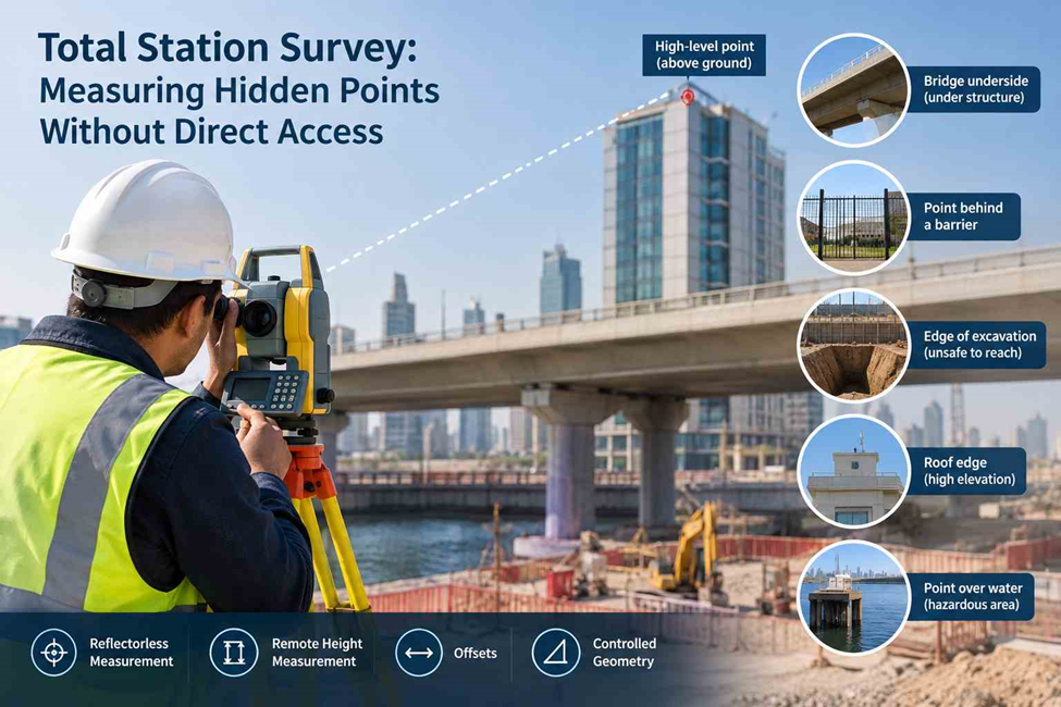
Not every survey point can be reached with a prism pole. A point may be high above the ground, behind an obstruction, or inside a restricted area.
A Total Station can measure many inaccessible points without placing a prism directly on them. Using reflectorless observations, remote height measurements, offsets, or suitable geometry, surveyors can determine the required position or elevation.
An inaccessible point is not always an unmeasurable point—provided there is a reliable line of sight and suitable survey geometry.
What Does “Hidden Point” Mean in Total Station Surveying?
In surveying, “hidden” does not always mean that the point is physically behind another object.
It can refer to any point that cannot be directly occupied or targeted with a prism in the normal way.
Examples include:
- The top of a high structure
- The underside of a bridge
- A building corner behind a fence
- A point inside a restricted compound
- The edge of a deep excavation
- A façade detail above a safe working height
- A point across an obstruction
- The elevation of a feature that cannot be physically reached
- A structural point over water or another hazardous area
The surveyor’s task is to determine which measurement method can obtain the required information without introducing unnecessary uncertainty.
Why Direct Access Is Not Always Necessary
A Total Station can measure more than points occupied with a prism. Modern instruments support reflectorless EDM and other methods that use measured geometry to determine inaccessible points.
For example, the elevation of a bridge underside can be measured remotely when direct access is restricted by traffic, water, or safety conditions. The appropriate method depends on the point and the accuracy required.
1. Reflectorless Measurement for Difficult Targets
Reflectorless EDM allows a Total Station to measure visible surfaces without placing a prism on the target.
It is useful for:
- Building façades
- Concrete walls
- Structural elements
- Retaining walls
- High-level features
A clear line of sight is still required. Dark, reflective, wet, or irregular surfaces can affect the measurement, so the surveyor must check whether the result meets the required accuracy.
2. Remote Height Measurement
Remote height measurement helps determine the elevation of points that are difficult or unsafe to reach.
It can be used for:
- Building elevations
- Pole and sign heights
- Bridge components
- Roof edges
- Overhead features
The surveyor uses measured angles and distances to calculate the required height. Accuracy depends on the instrument setup, target identification, and observation geometry.
3. Measuring Points That Cannot Be Occupied
A visible point may be unsafe or impossible to reach, such as the edge of a deep excavation.
The surveyor can observe it from stable ground using reflectorless measurement or a suitable offset method. This reduces the need for unnecessary physical access on active construction sites.
4. Using Offset Measurements
When the exact point cannot be occupied, a related accessible point can be measured and the required position calculated using a known offset.
Common offsets include:
- Horizontal
- Vertical
- Perpendicular
- Line-based
The offset must be clearly defined. An incorrect offset can produce a precise-looking but inaccurate coordinate.
5. Measuring Around Obstructions
Fencing, scaffolding, vehicles, and structures can block a direct line of sight.
Instead of repeatedly moving the Total Station, the surveyor can use another observation position, control point, or suitable measurement method while maintaining the established survey reference.
Good planning helps reduce unnecessary setups while keeping the measurements reliable.
The Difference Between “Not Reachable” and “Not Visible”
This is an important point when discussing inaccessible measurements.
Not reachable
The surveyor can see the point, but cannot safely or practically place a prism on it.
Examples:
- High façade point
- Bridge underside
- Point inside a restricted area
- Edge of an excavation
- Feature over water
A reflectorless or remote measurement technique may be suitable.
Not visible
The required point is completely blocked from the Total Station.
Examples:
- A building corner behind a solid wall
- A buried feature
- A point behind a large obstruction
- A structural element hidden by another structure
A Total Station cannot simply “see through” the obstruction.
Another survey method, additional observation points, physical access, or suitable indirect geometry may be required.
This distinction prevents unrealistic expectations from the equipment.
How Surveyors Decide Which Method to Use
The method is selected based on the point, not simply on the instrument’s available features.
Before measuring an inaccessible point, the surveyor should consider:
1. Is the point clearly identifiable?
There must be confidence that the observed location is actually the required point.
2. Is there a clear line of sight?
The Total Station needs an unobstructed measurement path for the selected observation method.
3. What accuracy is required?
A rough dimensional check and a construction-control measurement do not necessarily have the same tolerance.
4. Can the surface provide a reliable reflectorless return?
If the target surface is unsuitable, another technique may be preferable.
5. Is the instrument position stable?
A small setup problem can affect every measurement taken from that station.
6. Can the result be independently checked?
For important points, a second observation or alternative measurement can provide useful verification.
Example: Measuring a High-Level Building Feature
A contractor may need the elevation of a high-level building façade point where placing a prism is impractical.
The surveyor sets up the Total Station from a controlled position with a clear view, checks the orientation, and uses reflectorless or remote measurement techniques.
The result is then checked against project control and surrounding measurements. For critical points, a second observation can provide additional verification.
What Can Go Wrong With Inaccessible Measurements?
Remote measurements are useful, but they are not automatically accurate simply because the Total Station displays a coordinate.
Several issues can affect the result.
Incorrect target identification
The laser may be aimed at the wrong part of a surface, especially when the feature is small or visually unclear.
Poor observation angle
Unfavourable geometry can reduce the reliability of an indirect calculation.
Reflective or unsuitable surfaces
Glass, shiny materials, dark surfaces and irregular surfaces can produce difficult measurement conditions.
Incorrect instrument height
An incorrect instrument or target height can affect calculated elevations.
Weak control
If the survey is not properly connected to project control, the final coordinate may not be reliable.
Lack of verification
A single observation should not automatically be accepted for a critical construction point.
Good field practice includes checking measurements that appear unusual or are important to the project.
When Is a Total Station the Right Choice?
Total Station surveying is particularly useful where controlled point measurements are required around structures, construction areas and locations where direct physical access is limited.
Typical applications include:
- Structural surveys
- Building elevation checks
- High-level measurements
- Construction setting out
- As-built verification
- Bridge and infrastructure surveys
- Restricted-area measurements
- Detailed site surveys
- Control surveys
- Dimensional checks
For large open areas, GNSS may be more efficient for collecting a high volume of points. For detailed measurements around structures or locations with poor satellite visibility, a Total Station can provide a more controlled approach.
The best survey workflow may also combine Total Station observations with GNSS, levels, 3D laser scanning or other methods.
Final Thoughts
An inaccessible point does not always require physical access. With suitable Total Station techniques such as reflectorless measurement, remote height measurement and offsets, surveyors can obtain reliable data when line of sight and survey geometry are suitable.
The method should always match the required accuracy and site conditions, helping reduce difficult or unsafe access during construction surveys.
Need Total Station Survey Support?
Northern Engineering Surveys L.L.C. provides Total Station Survey, topographical survey, GPS/GNSS survey, setting out, control point surveys, as-built surveys and other land and engineering surveying services for construction and infrastructure projects in Dubai and across the UAE.
If your project includes high-level features, restricted areas, inaccessible points or detailed construction measurements, our survey team can assess the site conditions and recommend a suitable measurement approach.
Contact Northern Engineering Surveys L.L.C. to discuss your Total Station survey requirement.
Frequently Asked Questions
1. Can a Total Station measure a point without placing a prism on it?
Yes. If the point is visible and the instrument supports reflectorless measurement, certain surfaces can be measured without placing a prism directly on the point. The suitability depends on the surface, distance, viewing angle and required accuracy.
2. Can a Total Station measure the height of a building or pole?
Yes. Remote height measurement techniques can be used to determine the elevation or height of accessible and visible features. The surveyor establishes the required geometry from the instrument position and performs the appropriate calculation.
3. Can a Total Station measure through a wall?
No. A Total Station requires a suitable line of sight to the target. If the point is completely blocked by a wall or another obstruction, the surveyor needs another observation position or a different measurement method.
4. Is reflectorless Total Station surveying accurate?
Reflectorless measurement can provide accurate results when the target surface, distance, angle and instrument conditions are suitable. For critical measurements, the surveyor should assess the observation and carry out appropriate checks rather than relying on a single reading.
5. What is the difference between reflectorless and prism measurement?
Prism measurement uses a reflector placed at the survey point, while reflectorless measurement determines the distance from the instrument to a suitable surface without placing a prism there. Prism observations are often preferred where the required point can be safely occupied and higher confidence in target identification is needed.
6. What if the required point is completely hidden?
A Total Station cannot directly measure a point that it cannot observe. The surveyor may need to change the instrument position, establish additional control, use indirect geometry, or select another surveying technology depending on the project requirements.
7. Can inaccessible-point measurements be used for construction work?
Yes, provided the selected method is suitable for the required tolerance and the measurement is properly connected to project control. Critical construction points should also be checked according to the project’s survey procedures.