
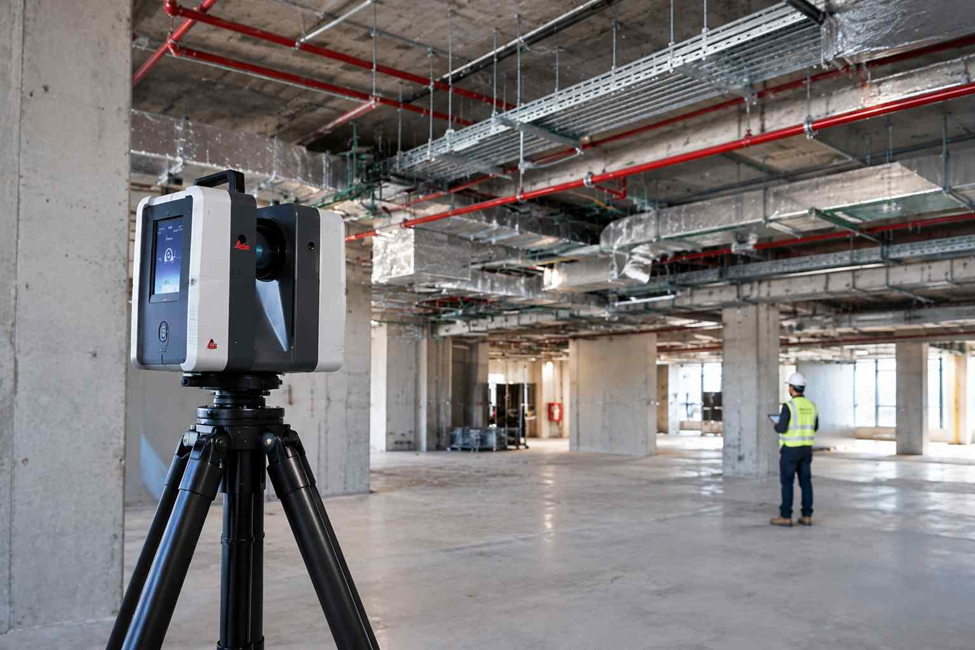
Old drawings rarely match what’s actually on site. Walls get moved, ducts get rerouted, and “as designed” quietly drifts away from “as built.” When that gap shows up mid-renovation a clash between a new wall and an existing beam, a pipe run nobody documented it costs time and money to fix. An as-built survey using 3D laser scanning closes that gap before construction starts, not after.
What Is an As-Built Survey Using 3D Laser Scanning?
An as-built survey records the real, current condition of a building including every change made during construction rather than relying on the original design drawings.
3D laser scanning does this by capturing the site as millions of precise measurement points. In a single visit, it picks up walls, columns, beams, pipes, ducts, and floors, building a complete picture of the structure as it actually stands today.
That point cloud then becomes the source for accurate 2D drawings and 3D models, giving architects, engineers, and contractors a reliable base to plan renovation or fit-out work around instead of guessing where things really are.
Why teams use it:
- Pinpoints the exact position of walls, columns, and services
- Flags clashes between new work and existing MEP systems before they happen on site
- Gives renovation and refurbishment teams measurements they can actually trust
- Leaves a lasting record for future maintenance and facility management
Compared to manual surveying, scanning is faster, captures far more detail, and cuts the risk of missing something that only shows up once work is underway.
| Aspect | Manual Survey | 3D Laser Scanning |
| Data captured | Selected points, measured by hand | Millions of points, full surface coverage |
| Site time | Longer, especially on large or complex sites | Significantly faster per area covered |
| Accuracy | Depends on operator and access | Consistent, millimetre-level accuracy |
| Hidden/hard-to-reach areas | Often missed or estimated | Captured from multiple scan positions |
| Output | Hand-drawn or basic CAD sketches | Point cloud ready for CAD, BIM, and 3D models |
| Rework risk | Higher — gaps surface mid-project | Lower — full dataset available upfront |
This is also why laser scanning has become the default choice for projects that need to submit BIM models against current regulatory requirements, not just a set of drawings.
How Does 3D Laser Scanning Capture As-Built Conditions?
The scanner works from multiple positions around the site, layering overlapping scans until the whole structure is covered.
- Scan positions are planned around the site layout before work begins
- Overlapping coverage closes gaps and improves accuracy
- Extra scans target areas hidden behind walls, columns, or equipment
- Walls, floors, ceilings, columns, and beams are captured directly
- Doors, windows, pipes, ducts, cable trays, and equipment are picked up in the same pass
- Every scan is registered together into one accurate as-built model
Can 3D Laser Scanning Produce As-Built CAD Drawings?
Yes — and this is usually the end goal, not the scan itself. Getting there takes three steps:
- Point cloud creation. The scanner records millions of points, capturing the exact position and shape of walls, floors, ceilings, structural elements, and MEP services.
- Data extraction. The point cloud is reviewed and the relevant building, structural, and MEP details are pulled out for documentation.
- CAD documentation. That data becomes the finished deliverables floor plans, sections, elevations, MEP layouts, and structural drawings, drawn to match what’s actually on site.
Why This Matters More in the UAE Right Now
Dubai Municipality’s BIM mandate (Circular 9-1-2) now requires a BIM model to be submitted alongside new building permit applications, and municipal guidance is increasingly expecting existing-conditions models for major retrofit and renovation work as well — not just new builds. Full circular details are published on Dubai Municipality’s official site (dm.gov.ae).
For any renovation, fit-out, or retrofit project that falls under this requirement, an as-built laser scan is the fastest and most accurate way to produce that existing-conditions BIM model turning a regulatory requirement into a dataset you’d want anyway.
Where Is As-Built Laser Scanning Used?
Building surveys — Scanning walls, floors, columns, and openings to produce accurate floor plans and verify real dimensions before design work starts, and to leave a digital record once construction wraps up.
MEP surveys — Plant rooms, ceiling voids, and service corridors are often the most crowded, hardest-to-measure spaces on a site. Scanning captures pipes, ducts, cable trays, and equipment in these areas so new MEP work can be coordinated around what’s already there.
Industrial surveys — Tanks, steel structures, platforms, and pipework in large plant facilities are surveyed in detail, giving engineers a reliable base for upgrades, new equipment, or updated BIM models.
Renovation and fit-out surveys — Capturing a space before work begins means room sizes, wall positions, and ceiling levels are confirmed against reality, not assumed from old drawings avoiding surprises once installation starts.
Brownfield surveys — On older industrial sites where drawings are missing or outdated, scanning captures the current layout of equipment, structures, and pipework, forming the basis for upgrade or redevelopment plans.
What Affects the Quality of an As-Built Laser Scan?
Not every scan delivers the same result. Quality comes down to how the work is planned, captured, and checked:
- Scan position — locations need to be chosen so every wall, structure, and piece of equipment is captured from a usable angle
- Line of sight — a blocked view means incomplete data for that surface
- Occlusion — columns, machinery, and pipework can hide what’s behind them, so extra scan positions are sometimes the only fix
- Coverage — overlapping scans need to add up to full coverage, with no major gaps
- Surface visibility — dark, reflective, or highly textured surfaces can affect how cleanly the laser reads them
- Registration quality — scans that aren’t aligned accurately introduce shifts and measurement errors downstream
- Survey control — reliable control points tie the scan to known site coordinates
- Coordinate system — using the correct project datum and grid keeps the point cloud positioned correctly
- Level of detail — scan density should match the end use, whether that’s basic documentation or full BIM modelling
- Verification — key measurements should be checked against site conditions before the data is signed off
How Does an As-Built Laser Scan Support Retrofit Projects?
Retrofit work lives or dies on how well it fits around what’s already there. A laser scan gives retrofit teams that picture upfront turning the existing space into a point cloud that feeds directly into CAD or BIM, so decisions are based on actual conditions rather than drawings that may no longer be accurate.
- Existing pipe routes are mapped so new pipework can be planned without clashing with what’s already running
- Equipment locations tanks, machinery, ducts are captured and positioned accurately within the project area
- Available clearances around equipment and access routes are confirmed before new components are introduced
- Structural constraints columns, beams, slabs, and openings are identified early so the design works around them, not against them
- Connection points for pipes, ducts, and equipment are reviewed to find the best locations for new tie-ins
- Ceiling services, often the hardest to measure by hand, are captured in full ducts, pipes, and cable trays included
- New MEP routing can be planned against the existing scan to catch clashes before installation
- Replacement planning benefits from confirmed space, access, and installation requirements ahead of time
Surveying Services by NES Dubai
Northern Engineering Surveys L.L.C. (NES) provides surveying services in Dubai, including 3D Laser Scanning, Topography, As-Built Survey, and Volume Calculation.
Need accurate survey data for your project? Contact NES Dubai for your surveying requirements.